
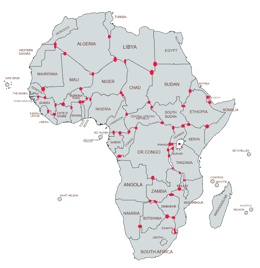
A tripoint, is a geographical point at which the boundaries of three countries meet. These can be on land (dry) or demarcated by rivers or lakes (wet). Tripoints can be easy to access or isolated, they can be marked with large monuments or not easily identifiable at all. There are 61 African Tripoints which is the most of any continent.

Table: African Tripoints
| Number | Name | Countries | Coordinates | Type | Links/Notes |
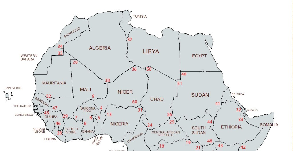
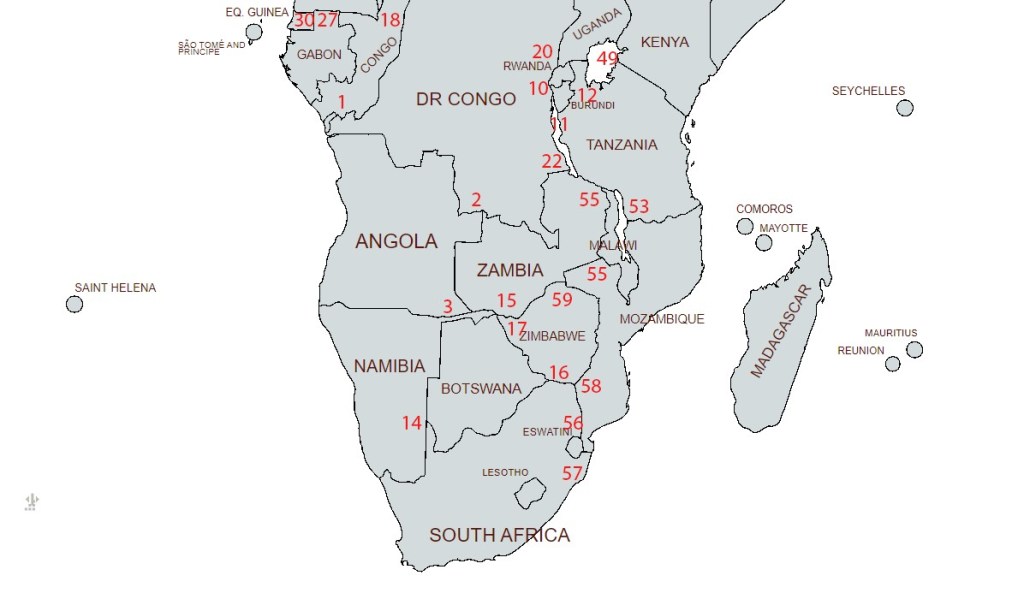
| 1 | AOCDCG | Angola – Democratic Republic of the Congo – Republic of the Congo | 4°41’7″S 13°6’7″E | Wet | This tripoint is located in the Cabinda exclave of Angola. Tripoint located in the Chiloango river at its confluence with the Bidihimba. Access possible via a rough dirt track. The river divides the Democratic Republic of the Congo from the Republic of the Congo above the tripoint & from the Angolan exclave below it. |
| 2 | AOCDZM | Angola – Democratic Republic of the Congo – Zambia | 10°53’26″S 24°0’3″E | Dry | Isolated, rural with no distinguishing physical features. All borders are demarcated and the tripoint is likely to be BM#46 on the CDZM border and BM#1 on the AOZM border. |
| 3 | AONAZM | Angola – Namibia – Zambia | 17°38’16″S 23°26’3″E | Dry/Wet | The tripoint is located at Triune Point on the eastern bank of the River Kwando. Close to the Imusho border crossing between NAZM |
| 4 | BFBJNE | Benin – Burkina Faso – Niger | 11°54’2″N 2°24’14″E | Wet | The tripoint is located on the Mékrou River, |
| 5 | BFBJTG | Benin – Burkina Faso – Togo | 11°0’0″N 0°55’0″E | Wet | The exact location of the tripoint is complicated by the existance of the Koalou neutral zone between BFBJ. High levels of insecurity. |
| 6 | BFCIGH | Burkina Faso – Ivory Coast – Ghana | 9°29’38″N 2°41’18″W | Wet | The tripoint is located on the Black Volta river |
| 7 | BFCIML | Burkina Faso – Ivory Coast – Mali | 10°25’52″N 5°30’49″W | Wet | The tripoint is located at the confluence of the Léraba and Bani rivers. |
| 8 | BFGHTG | Burkina Faso – Ghana – Togo | 11°8’22″N 0°8’11″W | Wet | The tripoint is located in the normally dry bed of the of the Kulutamsi river. The tripoint is defined as pillar 148 in the Anglo French demarcation (1930). |
| 9 | BFMLNE | Burkina Faso – Mali – Niger | 14°55’3″N 0°14’6″E | Dry | Located within the Liptako Gourma region with high levels of insecurity. In 1986 the tripoint was agreed to be at Mount Ngouma (1882m). |
| 10 | BICDRW | Burundi – Democratic Republic of the Congo – Rwanda | 2°44’40″S 29°2’26″E | Wet | The tripoint is located at the junction of the Rusizi and Ruwa rivers between Lake Tanganyika and Lac Kivu. There are no known treaties establishing the tripoint, and the Burundi – Rwanda border appears to be a traditional line between the two states. |
| 11 | BICDTZ | Burundi – Democratic Republic of the Congo – Tanzania | 4°26’36″S 29°25’9″E | Wet | The tripoint is located in the middle of Lake Tanganyika due west of BEGB pillar number 1 at mouth of the Ndyakalika ravin. |
| 12 | BIRWTZ | Burundi – Rwanda – Tanzania | 2°24’46″S 30°32’34″E | Wet | The tripoint is located at the confluence of the Mwibu and Kagera rivers |
| 13 | BJNENG | Benin – Niger – Nigeria | 11°41’45″N 3°36’24″E | Wet | The tripoint is located in the Niger River,, west of Madekali (BJ). |
| 14 | BWNAZA | Botswana – Namibia – South Africa | 24°45’50″S 20°0’0″E | Wet | The tripoint is located where the Nossob River crosses the 20th meridian east |
| 15 | BWNAZM | Botswana – Namibia – Zambia | 17°47’26″S 25°15’42″E | Wet | The Botswana–Zambia border connects two tripoints on the Zambezi River, one with Namibia in the northwest to one with Zimbabwe in the southeast. This incredibly short land boundary on the Zambezi River is also known as the quadripoint area. Near Kasane (Four Corners) |
| 16 | BWZAZW | Botswana – South Africa – Zimbabwe | 22°11’39″S 29°22’38″E | Wet | The tripoint is located at the confluence of Shashe River and Limpopo River |
| 17 | BWZMZW | Botswana – Zambia – Zimbabwe | 17°47’27″S 25°15’45″E | Wet | The Botswana–Zambia border connects two tripoints on the Zambezi River, one with Namibia in the northwest to one with Zimbabwe in the southeast. This incredibly short land boundary on the Zambezi River is also known as the quadripoint area. Near Kasane (Four Corners) |
| 18 | CDCFCG | Central African Republic – Democratic Republic of the Congo – Republic of the Congo | 3°28’48″N 18°38’24″E | Wet | The tripoint is located at the confluence of the Gouga river and Ubangi river. Close to the village of Mongoumba CD |
| 19 | CDCFSS | Central African Republic – Democratic Republic of the Congo – South Sudan | 5°1’14″N 27°27’13″E | Dry | Possibly marked by a large pile of rocks (a pre existing colonial marker from 1924). Possible access via tracks from Ezo (SS). |
| 20 | CDRWUG | Democratic Republic of the Congo – Rwanda – Uganda | 1°23’21S 29°35’28E | Dry | Mount Sabyinyo (3669m) an extinct volcano marks the tripoint. A sign marks the point. |
| 21 | CDSSUG | Democratic Republic of the Congo – South Sudan – Uganda | 3°30’0″N 30°51’0″E | Dry | Defacto tripoint in the village of Salia Musala marked by an imposing tree. |
| 22 | CDTZZM | Democratic Republic of the Congo – Tanzania – Zambia | 8°12’S 30°46’E | Wet | The median line of Lake Tanganyika forms the border between CD/TZ. Tripoint located in the south of the lake east of Moliro CD |
| 23 | CFCGCM | Cameroon – Central African Republic – Republic of the Congo | 2°12’59″N 16°11’38″E | Wet | The tripoint is located in the Sangha River, north of Bomassa CG |
| 24 | CFCMTD | Cameroon – Central African Republic – Chad | 7°31’42″N 15°29’36″E | Wet | The tripoint is located at the center of the Mbere River |
| 25 | CFSDSS | Central African Republic – South Sudan – Sudan | 9°40’08″N 23°41’46″E | Dry | Disputed. The Kafia Kingi region, is contested between Sudan and South Sudan. This leaves the exact location of the southern tripoint in dispute, and almost 300 km of the eastern boundary of the CAR in flux between the two countries. |
| 26 | CFSDTD | Central African Republic – Chad – Sudan | 10°56’8″N 22°52’22″E | Wet | The tripoint is situated in a small stream immediately east of the Mare de Tizi. Very close to a border crossing station SD/CF |
| 27 | CGCMGA | Cameroon – Gabon – Republic of the Congo | 2°10’10″N 13°17’39″E | Wet | The tripoint is in the Lvindio river which marks the GA border. CG border with CM intersects E to W. |
| 28 | CIGNLR | Ivory Coast – Guinea – Liberia | 7°33’26″N 8°28’13″W | Dry | The tripoint is 8km SW of the summit of Mount Nimba (1752m) |
| 29 | CIGNML | Ivory Coast – Guinea – Mali | 10°10’21″N 7°58’50″W | Dry | Rural location. Unmarked no identifiable physical features. Possibly based on a drainage divide. |
| 30 | CMGAGQ | Cameroon – Equatorial Guinea – Gabon | 2°10’20″N 11°20’0″W | Wet | The location is not clear however the defacto borders seem to follow local rivers east of the position outlined in the treaty. At or near the confluence of the Kye & Mvezeu rivers on the CMGQ border. |
| 31 | CMNGTD | Cameroon – Chad – Nigeria | 13°5’N 14°5*E | Wet | Located in a dry part of Lake Chad, east of Allah Karrim (NG). |
| 32 | DJERET | Djibouti – Eritrea – Ethiopia | 12°28’7.1″N 42°24’15.40″E | Dry | Mount Musa Ali (2028m) established by the Eritrea-Ethiopia Boundary Commission (2002). Near BM#92 DJET |
| 33 | DJETSO | Djibouti – Ethiopia – Somalia | 10°59’50″N 42°58’3E | Dry | The tripoint is on the summit of Madaha Djalelo (394m). BM#1 is located there. |
| 34 | DZEHMA | Algeria – Morocco – Western Sahara | 27°40’N 8°40’W | Dry | The DZEH boundary was delimited and demarcated by a Franco–Spanish boundary commission in the early 1900s and again from 1956–1958 and is marked by two boundary markers. One might be the TP. The Western Sahara is however a contested with Morocco claiming ownership. The 1991 cease fire collapsed in 2020. Algeria broke off diplomatic relations with Morocco in 2021. |
| 35 | DZEHMR | Algeria – Mauritania – Western Sahara | 27°18’N 8°40’W | Dry | The Algeria–Mauritania boundary extends to the meridian of 8° 40′ W. at approximately 27° 17′ 40″ N. The tripoint is located on the north bank of a wadi which drains eastward to Tindouf in Algeria. |
| 36 | DZLYNE | Algeria – Libya – Niger | 23°30’N12°0’E | Dry | Located on the Garet Derouel el Djemel ridge at 1010m. Possibly marked by geodensic point. |
| 37 | DZLYTN | Algeria – Libya – Tunisia | 30°14’N 9°32’E | Dry | South of Borj el Khadra. The Algeria-Libya-Tunisia tripoint usually is considered to be located between pillars 220 and 221 on the DZLY border, of the demarcation of 1910-11 at about 30° 13.5′ N. and 9° 33.5′ E. |
| 38 | DZMLNE | Algeria – Mali – Niger | 19°8’43″N 4°16’E | Dry | Unmarked. The tripoint is not exactly fixed owing to a lack of demarcation of all 3 convergent boundaries. Differing maps have differing locations. |
| 39 | DZMLMR | Algeria – Mali – Mauritania | 25°0’N 4°50’W | Dry | Unmarked. Lack of border demarcation. Position broadly agreed. Maps differ however. |
| 40 | EGLYSD | Egypt – Libya – Sudan | 22°00’N 25°00’E | Dry | Tripoint was fixed by 1925 Italo Egyptian treaty. Unmarked, isolated point in the Sahara desert. Dafur region of Sudan. |
| 41 | ERETSD | Eritrea – Ethiopia – Sudan | 14°15’28″N 36’33’37E | Wet | Previously affected by the Al-Fashaga conflict (settled in 2008). Located in the Tekeze River near where the river turns west from its previously north south orientation. |
| 42 | ETKESO | Ethiopia – Kenya – Somalia | 3°58’58″N 41°54’25″E | Wet | The tripoint is located in the Dawa River where the Ethiopia – Kenya border (W-E) meets the Somalia border (N-S). |
| 43 | ETKESS | Ethiopia – Kenya – South Sudan | 4°37’52″N 35°56’56″E | Dry | Disputed – Ilemi Triangle dispute between Kenya and South Sudan. A remaining 214 km of boundary with Ethiopia is claimed by both South Sudan and Kenya. Possible location at ETKE pillar d23 1970 |
| 44 | ETSDSS | Ethiopia – Sudan – South Sudan | 9°30’N 34°6’24″E | Dry | Unmarked. Located in the Illemi Triangle disputed area between Kenya and South Sudan. |
| 45 | GNGWSN | Guinea – Guinea-Bissau – Senegal | 12°40’30″N 13°42’30″W | Dry | Marked with BM#58 on the Guinea-Bissau – Senegal border. |
| 46 | GNLRSL | Guinea – Liberia – Sierra Leone | 8°29’6″N 10°16’44″W | Wet | The tripoint is located where the borders of Guinea – Sierra Leone meet those of Liberia – Sierra Leone on the bank of the Moa River. Marked by cairn or pillar 1 of the 1911 Anglo – Liberian survey |
| 47 | GNMLSN | Guinea – Mali – Senegal | 12°24’46″N 11°22’37″W | Wet | The tripoint with Senegal is where its border with Guinea (that follows the crest of the Konkoniouma mountains) meets the Mali- Guinea border in the Balinko river |
| 48 | KESSUG | Kenya – South Sudan – Uganda | 4°13’29″N 33°59’11″E | Dry | Unmarked. An isolated spot. North of Mt Zulia. |
| 49 | KETZUG | Kenya – Tanzania – Uganda | 1°0’S 33°56’E | Wet | Lake Victoria |
| 50 | LYNETD | Chad – Libya – Niger | 23°00″N 15°00’E | Dry | Unmarked. Isolated point in the Sahara Desert. |
| 51 | LYSDTD | Chad – Libya – Sudan | 19°30’N 24°00’E | Dry | Isolated point in the Sahara Desert. Possibly indicated by a heap of stones at junction of 3 otherwise undemarcated boundaries. |
| 52 | MLMRSN | Mali – Mauritania – Senegal | 14°45’51″N 12°14’24″W | Wet | Situated and the confluence of the Faleme and Senegal rivers. |
| 53 | MWMZTZ | Malawi – Mozambique – Tanzania | 11°34’25″S 34°57’34″E | Wet | Disputed. Malawi claims approximately 360 km of shoreline boundary, while Tanzania calls for the boundary to extend along the median line of Lake Malawi/Nyasa for approximately 230 km. |
| 54 | MWMZZM | Malawi – Mozambique – Zambia | 13°59’54″S 33°14’32″E | Dry | The intersection of the Lake Nyasa–Zambezi drainage divide with the 14th parallel was marked by pillar No. 38, which is the site of the present-day tripoint. The 1904 demarcation was approved by an Anglo–Portuguese agreement of October 21–November 20, 1911. |
| 55 | MWTZZM | Malawi – Tanzania – Zambia | 9°24’S 32°57’30″E | Dry | The Malawi–Tanzania–Zambia tripoint is located on Nankungulu hill. In delimiting the boundary between Lake Nyasa and Lake Tanganyika, an Anglo–German protocol of November 11, 1898, agreed that Nankungulu was located on the watershed of the Congo basin in accordance with the terms of the agreement of July 1, 1890. Marked with a pillar #2. |
| 56 | MZZASZn | Mozambique – South Africa – Eswatini (north) | 25°57’9″S 31°58’31″E | Dry | Mpundweni Beacon near Namaacha. Marked with a large stone cairn with a capstone. |
| 57 | MZZASZs | Mozambique – South Africa – Eswatini (south) | 26°50’24″S 32°08’4″E | Wet | The southern Eswatini tripoint is situated at Abercorn Drift in the Usutu River (Maputo River), where the Mozambique–Eswatini border along the Lebombo Mountains meets the river. |
| 58 | MZZAZW | Mozambique – South Africa – Zimbabwe | 22°25’25″S 31°18’26″E | Wet | The tripoint is located at Crooks’ Corner, in the Limpopo River either at or very close to its confluence with the Luvuvhu River. |
| 59 | MZZMZW | Mozambique – Zambia – Zimbabwe | 15°37’16″S 30°25’19″E | Wet | The tripoint is located at the confluence of the Zambezi River with the Luangwa River close to LUANGWA HARBOUR. GBPT BM#1 on the south bank 200m east. |
| 60 | NENGTD | Chad – Niger – Nigeria | 13°42’30″N 13°38’E | Wet | The tripoint is located in northern Lake Chad, possibly in line with the Komadugu yobe River about 1km south of the village of Bosso Niger. |
| 61 | RWTZUG | Rwanda – Tanzania – Uganda | 1°3’26″S 30°28’24″E | Wet | The Anglo – German agreement of 1910 and the Anglo – Belgian protocol 1924 locate the tripoint at the junction of the thalweg of the Kakitumba and the midstream of the Kagera. |
Supplementary information including treaties and maps Details here or click on the image above,
Map of African Tripoints
Northern Africa
Southern Africa
Tripoint Visit Classes
The table below attempts to classify a tripoint visit into a number of classes. Could you touch the actual spot where the countries join? If so that is a Class A, a visit to a wet tripoint is almost always a Class C. Some monuments such as FINOSE the tripoint between Finland – Norway and Sweden is too large to touch the stone on the top, hence a Class B. Not everyone uses this classification and it is offered here as a bit of fun to stimulate discussion.
| Tripoint VISIT Classes | |
|---|---|
| Class A | Touched |
| Class B | Basically there. Successful attempt to reach wet tripoint by wading, swimming or canoeing. Very close to a dry tripoint but unable to touch due to a physical barrier/obstacle. |
| Class C | Within 500m, visible |
| Class D | Distant. visible |
| Class E | Tripoint area visited but Tripoint not observed. |
| Source: Acroorca (2002) Published on Boundarypoint 12/07/2003. Edited Arnold (2024). |
My Tripoint Gallery (0 out of 61 visited so far)
The International Standard for country codes and codes for their subdivisions is ISO 3166 this allocates a 2 letter designation to each country. When identifying a tripoint it is necessary to collate the 3 country codes in alphabetical order, hence the tripoint between Angola, Democratic Republic of the Congo and the
Republic of the Congo becomes AOCDCG. The US and Canada often use 2 letters to denote states and provinces e.g. Alabama AL which is technically incorrect as all sub national territories according to ISO 3166 should have the initial 2 letter country designation followed by up to 3 further letters. Alabama ought therefore be US- AL. Delaware has the same 2 letter code as Germany: DE which has the potential for confusion.
Please click on the photos below to access the reports of my visits, or the red highlighted text above.
Tripoints 1-20
Tripoints 21-40
Tripoints 41-61
Site Navigation
In order to find your way around the site, either click on the links (text in red) or use the menus at the top of the page. About leads you to the country pages, with links to individual borders. The about menu leads you to my visit reports by country.

Mobile Users Advice
Tables display correctly when holding your mobile horizontally.
To access the links to other pages please click on the 3 horizontal dots at the bottom of the page.
References
- African tripoints. Text by Michael Donner. Edited by Jesper Nielsen Details here
