
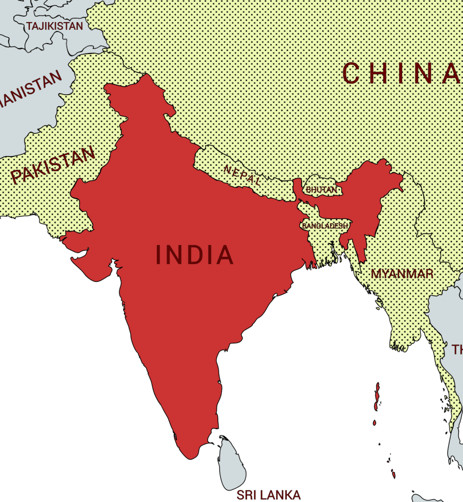
India, officially the Republic of India (Hindi: Bhārat Gaṇarājya), is a country in South Asia. India covers 2,973,193 square kilometers of land and 314,070 square kilometers of water with a total area of 3,287,263 square kilometers. It is the second-most populous country, the seventh-largest country by area, and the most populous democracy in the world. Bounded by the Indian Ocean on the south, the Arabian Sea on the southwest, and the Bay of Bengal on the southeast, it shares land borders with Pakistan to the west; China, Nepal, and Bhutan to the north; and Bangladesh and Myanmar to the east. In the Indian Ocean, India shares a maritime border with Sri Lanka; its Andaman and Nicobar Islands share a maritime border with Thailand and Indonesia.
Direct administration by the British, which began in 1858, effected a political and economic unification of the subcontinent. When British rule came to an end in 1947, the subcontinent was partitioned along religious lines into two separate countries. India, with a majority of Hindus, and Pakistan, with a majority of Muslims; the eastern portion of Pakistan later split off to form Bangladesh. Many British institutions stayed in place (such as the parliamentary system of government); English continued to be a widely used lingua franca; and India remained within the Commonwealth. Hindi became the official language (and a number of other local languages achieved official status) although English remains a unifying language.
India remains one of the most ethnically diverse countries in the world. Apart from its many religions and sects, India is home to innumerable castes and tribes, as well as to more than a dozen major and hundreds of minor linguistic groups from several language families unrelated to one another. Religious minorities, including Muslims, Christians, Sikhs, Buddhists, and Jains, still account for a significant proportion of the population.
India is a developing country, a nuclear power, has launched satellites and has large industrial and cultural sectors. It nevertheless has a low GDP and large scale social inequality. Economic disadvantages, social and gender inequality as well as poor education and health systems means there is much more still to do.
Border Facts: India’s borders, which is roughly one-third coastline, joins six countries. It is bounded to the northwest by Pakistan, to the north by Nepal, China, and Bhutan; and to the east by Myanmar (Burma). Bangladesh to the east is surrounded by India to the north, east, and west. The island country of Sri Lanka is situated some 40 miles (65 km) off the southeast coast of India across the Palk Strait and Gulf of Mannar. Visiting border areas in India is very difficult because of the inhospitable terrain and the security situation meaning that there are many checkpoints and the borders are closed areas for tourists especially and in some cases Indian citizens too.
India -Pakistan border established in 1947 and was based on the Radcliffe Line which divided the states of Punjab and Bengal. The division led to inter communal fighting with the consensus that 1 m people died. Since the independence of India and Pakistan, the border has been a site of numerous conflicts and wars between each country, and is one of the most contested borders in the world. The border’s total length is 3,323 km, it is also one of the most dangerous borders in the world, based on an article written in the Foreign Policy in 2011. It can be seen from space at night due to the 150,000 flood lights installed by India on about 50,000 poles.
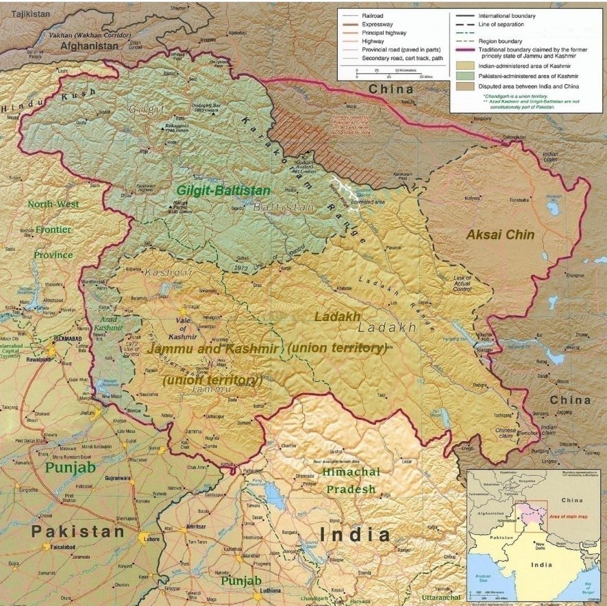
The border between the two Nations is an internationally recognised frontier from Gujarat/Sindh only with exemption to the Line of Control that is not internationally accepted. The disputed region of Kashmir got divided through the Indo-Pakistani War of 1947 into the regions of Pakistan-administered Kashmir and Indian-administered Kashmir. The UN-mediated ceasefire line of 1949 served as the de facto border between the two regions, which was revised to a Line of Control after the Indo-Pakistani War of 1971.
The whole area is contested with Pakistan claiming the predominately Muslim area of Kashmir as theirs. Contrastingly, India claims Azad Kashmir and Gilgit–Baltistan.
Border clashes occur relatively frequently. When travelling in Ladakh, I visited Turtuk which whilst controlled by India is geographically part of Baltistan and had been controlled by Pakistan up to 1971. The population is predominately Muslim. Although I had a police permit to be in the area, the army were not allowing any further progress to the LOAC – so frustrating but Indian tourists have only been allowed since 2018. (see this news article for further information). Details of my trip to Turtuk are here.
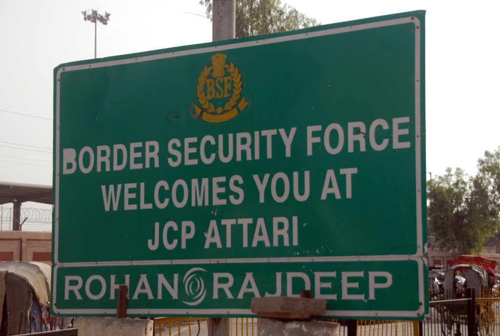
For a very long border there are very few border crossing between India and Pakistan. At time of writing there are only 3, although it is not clear if all of them are open. The most famous is the Wagah-Attari border crossing where each evening there is an elaborate border closing ceremony. I visited this crossing in 2012 and details of my visit are available here. Suchetgarh, Jammu has a similar but smaller ceremony as does the closed border crossing at Hussainiwala. There are also 2 rail crossings one at the Attari border and another in the Thar desert at the Munabao-Khokhrapar border crossing.
India – China Border

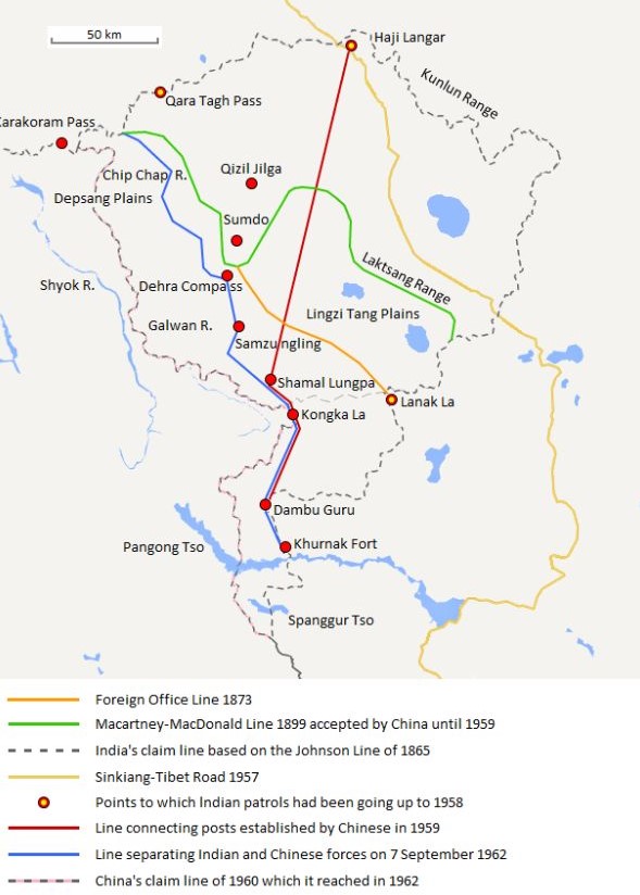
The India – China border is contested. The border (including the western LOAC, the small undisputed section in the centre, and the MacMahon Line in the east) is 4,056 km long and traverses one Indian union territory – Ladakh and four Indian states: Uttarakhand, Himachal Pradesh, Sikkim and Arunachal Pradesh. On the Chinese side, the line traverses the Tibet Autonomous Region. The demarcation existed as the informal cease-fire line between India and China after the 1962 war until 1993, when its existence was officially accepted as the ‘Line of Actual Control’ in a bilateral agreement.
Although no official boundary had ever been negotiated between China and India, the Indian government claims a boundary in the western sector similar to the Johnson Line of 1865, whereas the PRC government considers a line similar to the Macartney–MacDonald Line of 1899 as the boundary.
Sovereignty over two separated pieces of territory has been contested between China and India. Aksai Chin is located either in the Indian union territory of Ladakh or the Chinese autonomous region of Xinjiang and forms part of the Kashmir conflict. It is a virtually uninhabited high-altitude wasteland crossed by the Xinjiang-Tibet Highway. The other disputed territory lies south of the McMahon Line. It was formerly referred to as the North East Frontier Agency, and is now called Arunachal Pradesh. Ongoing border tensions and stands offs are a regular feature.
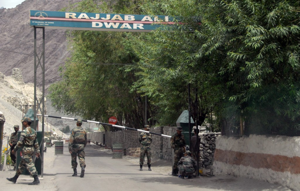
The whole border is very restricted and when I visited the border lake of Pangong Tso it was not possible to get within 50 km of the LOAC. Details of my visit are here.
Like the border for Pakistan, there are very few opportunities to view the border let alone cross it. Indian tourists are allowed to visit places like Nathu La in Sikkim and Shipki La in Himachal Pradesh but foreign tourists are not.
India – Nepal border is 1,690 km long established through the Sugauly treaty of 1816. Following Indian independence, the current border was recognized as the border between Nepal and Republic of India.
The India-Nepal border is relatively peaceful. After India achieved independence from the British in 1947, Nepal and India signed the Treaty of Peace and Friendship in 1950 and confirmed that the border between the two countries would remain open to the great advantage of the peoples of the two countries. As such, there is no need of passport or visa formalities among the border inhabitants or other nationals of Nepal and India. The nationals of one country can enter into the other country through the border not merely through the checkpoints but through any point.
There are two existing territorial disputes between India and Nepal, over the Kalapani territory, a 400 square kilometres (150 sq mi) area at the India-Nepal-China border in North West Nepal, and Susta a 140 square kilometres (54 sq mi) area in Southern Nepal. Ongoing protests occur the most recent in May 2020 when India completed a link road crossing the Kalapani territory.
India – Bangladesh border is 4,156-kilometre long, the fifth-longest land border in the world. It is based on the Radcliffe Line written in 1947. A number of pillars mark the border between the two states. Small demarcated portions of the border are fenced on both sides. The Land Boundary Agreement to simplify the border was ratified by both India and Bangladesh on 7 May 2015.
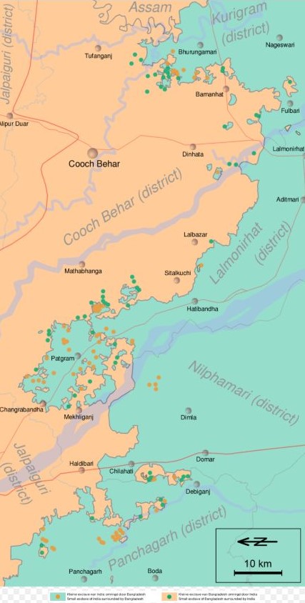
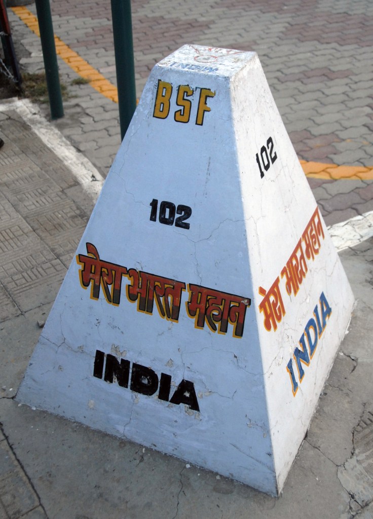
The border area between India and Bangladesh was characterised by an number of enclaves. Within the main body of Bangladesh were 102 enclaves of Indian territory, which in turn contained 21 Bangladeshi counter-enclaves, one of which contained an Indian counter-counter-enclave – the world’s only third-order enclave. Within the Indian mainland were 71 Bangladeshi enclaves, containing 3 Indian counter-enclaves. A joint census in 2010 found 51,549 people residing in these enclaves: 37,334 in Indian enclaves within Bangladesh and 14,215 in Bangladeshi enclaves within India. Over the years many of these enclaves were exchanged. In May 2015 a large scale land swap occurred. This resolved many challenges the inhabitants of the enclaves experienced in terms of access to services and citizenship.

Since the exchange of territory took place, the only remaining enclave is Dahagram–Angarpota, an exclave of Bangladesh. The enclave is connected to mainland Bangladesh by the Tin Bigha Corridor, which is situated in the town of Patgram Upazila. The corridor is closed for one hour every day so that the Border Security Force of India can raise the Indian flag in the corridor. BSF controls the corridor and the gates.
The border between the 2 countries is characterised by smuggling and illegal immigration and has been the site of conflict between the respective border and security services notably in 2001. In 2011 BSF forces were accused of indiscriminate killings including those of children.
There is a move towards the development of integrated border check points between the 2 countries.
India – Bhutan border is 699 km long, and adjoins the Indian states of Assam (267 km), Arunachal Pradesh (217 km), West Bengal (183 km) and Sikkim (32 km). The Treaty of Peace between Britain and Bhutan demarcated the border in 1865, following the Bhutan War. The boundary was further detailed and refined in the 1973-1984 period through talks between Bhutan and India. Remaining disputes have been minor and concern part of the border with Arunachal Pradesh, and the region between Sarbhang and Geylegphug. The border between Bhutan and India is the only land access into entering Bhutan, as the border with China is completely closed. The single entry point for foreign nationals is between the towns of Jaigaon in the Indian state of West Bengal and Phuntsholing, in South West Bhutan.
The Indian government deploys 12 battalions of Sashastra Seema Bal (SSB), and 132 border posts, to guard the border on its side. The bilateral Indian-Bhutan Group Border Management and Security has been established to collaboratively assess and secure the border between the two countries. Following the 2017 China–India border standoff, the Indian government increased the number of border posts.
India and Bhutan enjoy a special relationship with Bhutan being a “protected state”.
India – Myanmar border is 1,624-kilometre long. It has a free movement regime that gives the locals along the border the freedom to move about 10 miles across the border without a visa. The Indian government is currently building a barrier or border fence to tackle cross-border crime, including goods, arms and counterfeit currency smuggling, drug trafficking, and insurgency. The Indo-Myanmar Border Force (IMBF) is a proposed and soon-to-be-composed force of 29 battalions, 25 battalions from Assam Rifles and 4 battalions from Indo-Tibetan Border Police, to guard the border. Road and infrastructure links between the 2 countries are being developed and border crossings upgraded.
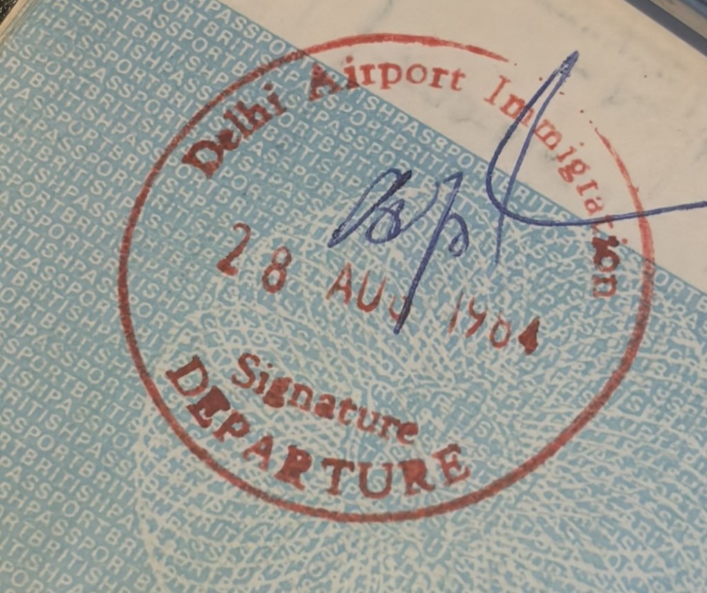
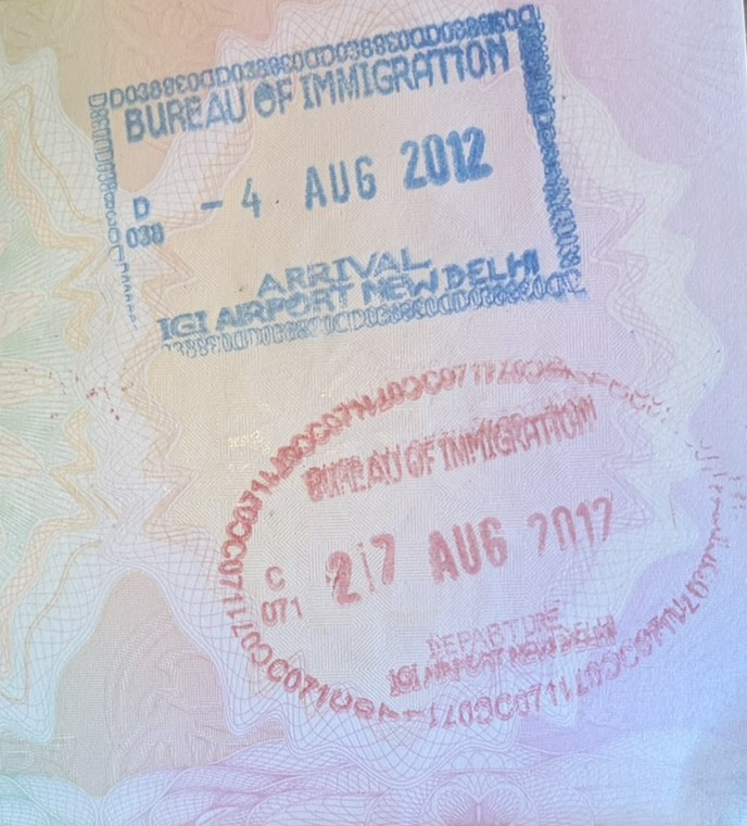
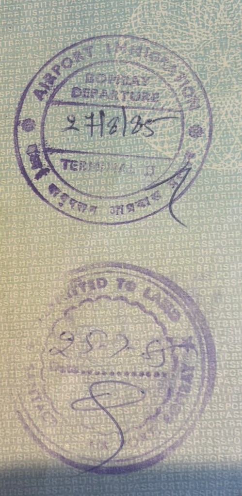
Indian Passport Stamps

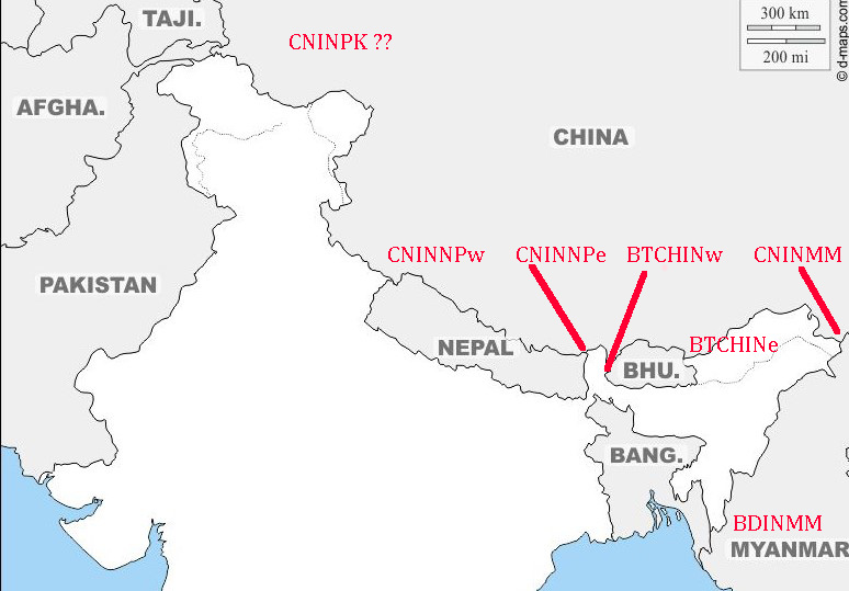
Indian Tripoints
| Number | Name | Countries | coordinates | Type | Notes/Links |
|---|---|---|---|---|---|
| 1 | BDINMM | Bangladesh – India – Myanmar | 21°58′N 92°36′E | Dry | Tin Mukh located on Teen Matha (876m). Access from Sepru Para village. Guides recommended. Marked by a pillar with names and flags of the respective countries. |
| 2 | BTCNINe | Bhutan – China – India (east) | 27°46′N 91°39′E | Dry | Disputed. Isolated high altitude point in the Himalayas. Tawang district in Arunachal Pradesh is adjacent to the border and tripoint area. |
| 3 | BTCNINw | Bhutan – China – India (west) | 27°20′N 88°55′E | Dry | Disputed. Doklam Plateau dispute. The tripoint is located just north of Mount Gipmochi (4427m). China claims Gipmochi as the China–India–Bhutan tri-junction point. Bhutan and India, however, claim that the tri-junction is 6.5 km to the north, at Batang La. |
| 4 | CNINMM | China – India – Myanmar | 28°13′N 97°21′E | Dry | Disputed. Diphu Pass is agreed by CNMM however IN believe the tripoint should be 5km further north on the watershed. Diphu Pass lies on the McMahon Line line. |
| 5 | CNINNPe | China – India – Nepal (east) | 27°53′N 88°8′E | Dry | The tripoint is possibly located on the summit of Jongsang peak (7463m). This is highest tripoint in the world. The Nepalese believe the tripoint is at Jhinsang Chuli (6164m) 27°50′10N 88°12′30E |
| 6 | CNINNPw | China – India – Nepal (west) | 30°12′N 81°2′E | Dry | Disputed. Both India and Nepal claim the Kalapani area, currently under Indian juristiction. The tripoint is possibly located near the Tinkar Pass at the watershed between Mapchu & Kali river & its Tinkar tributary. The Nepalese believe the tripoint is located at Limpiyadhura (5516m). 30°25′10 N 80°30′15 E. Map 1 |
| 7 | CNINPK | China – India – Pakistan | 35.6°N 76.8°E | Dry | The tripoint is located about a kilometre southeast of the Sia Kangri summit (7422m) in the Karakoram. Territories on all sides are disputed. The land immediately to the southwest of the peak is claimed by both Pakistan and India and controlled by Pakistan. The land to the northeast is part of the Trans-Karakoram Tract, controlled by China under a 1963 border agreement with Pakistan but is claimed by India. The land to the southeast is claimed by Pakistan and India, but controlled by India, as a part of Ladakh. |

Site Navigation
In order to find your way around the site, either click on the links (text in red) or use the menus at the top and side of the pages. About leads you to the main areas of the site. The European Tripoints menu leads directly you to my TP visits reports whereas the Country Visits page allows you to choose which country to look at first.

Tables display correctly when holding your mobile horizontally.
To access the links to other pages please click on the 3 horizontal dots at the bottom of the page.

