


Lithuania (Lithuanian: Lietuva) is one of the Baltic States along with Estonia and Latvia. It is bordered by Latvia to the north, Belarus to the east and south, Poland to the south, and Kaliningrad Oblast (a Russian exclave) to the southwest. The borders of Lithuania have moved substantially over the centuries, during the 14th century, the Grand Duchy of Lithuania was the largest country in Europe; from 1569 Lithuania was part of commonwealth with Poland that lasted 200 years.
Modern day Lithuania was established in 1918, however during WW2 Lithuania was occupied firstly by the Soviet Union and then Germany and then after the war was annexed by the Soviet Union.
In 1990 Lithuania became the first of the Baltic States to declare independence, following the dissolution of the Soviet Union.

Lithuania is a fascinating country to visit with its proximity to Belarus, its divided villages, fortified borders and its history of annexation and occupation. I would not have seen as much nor have had such an insight without the help of my host on this visit Jan Krogh whose website has been so helpful as I develop my knowledge of borders and geographical points generally, both for this visit and subsequently.
Many thanks Jan!
Border Facts:

Lithuania – Latvia Border: The Latvia-Lithuania border is 453km long. It begins at the crossing between the borders of Belarus, Latvia and Lithuania, on Lake Drūkšiai near the town of Visaginas (Lithuania), and ends in the Baltic Sea. Running from east to west, a 30-kilometre portion is formed by the river Sventoji (Baltic). The border region is relatively sparsely populated, containing around 3 million inhabitants. The existance of the border dates back to the middle ages, however the current border dates from 1918. The two Baltic Republics jointly participate in the Interreg IV A “Latvia-Lithuania” programme, whose objective is to promote the sustainable socio-economic development of the cross-border region.
Lithuania – Belarus Border: The relationship between Lithuania and Belarus dates back to the period when they were both parts of the Grand Duchy of Lithuania. Both nations would later be part of the Russian Empire and the Soviet Union. The Belarus–Lithuania border is an international border almost 679 km in length between the Republic of Belarus (CIS member) and the Republic of Lithuania (EU member) and also serves as an outer border of the European Union and the western border of the Commonwealth of Independent States. The border is defined by the treaty of February 6 1995 between the two countries. The ground demarcation of the border was completed in 2007. Since 2004 the border has served as the outer border of the European Union and since 2007, the Schengen Area.
The border starts at the tripoint BTLTLV and crosses through several physical features such as River Apyvardė, Lake Apvardai, and the Dysna River, it ends at the BYLTPL tripoint.
Lithuania – Poland Border: is 104 km long, the border begins in the East at the tripoint formed by the borders of Belarus, Poland and Lithuania, initially closely following the Marycha river. It takes a north-westerly direction and crosses the Gaładuś lake. The border comes to an end at the tripoint (LTPLRU) of the borders of Russia (exclave of Kaliningrad), Poland and Lithuania. Cross border cooperation is on going in the areas of energy and both countries are members of the Interreg IV A “Lithuania–Poland” operational programme focusing on sustainable development.
Lithuania – Russia Border: The modern Lithuanian-Russian border was established after World War I. For the most part it follows the older border between former German province of East Prussia to the south with Russia to the north. The 227 km border border passes through some distinct physical features such as the Curonian Spit, the Neman River, Lake Vištytis, and Curonian Lagoon. During the period when Lithuania was part of the USSR, the boundary between Russia and Lithuania was considered an internal boundary. After the USSR broke up, Lithuania became an independent nation, and the boundary became external. There is a tripoint between Lithuania, Russia, and Poland LTPLRU.
Lithuanian Registration Plates


Lithuanian Tripoints

| Number | Name | Countries | Type | coordinates | notes/Links |
|---|---|---|---|---|---|
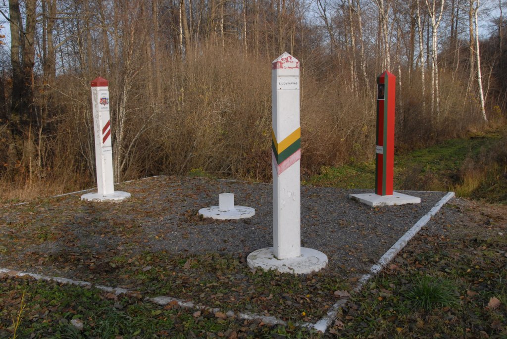
| 1 | BYLTLV | Belarus – Lithuania- Latvia | Dry | 55°40’50″N 26°37’49″E | The tripoint is named Liudevinova (BY), Ludvinova (LV) and Liudvinavas (LT) and is situated in a park on the Lithuanian side with sculptures and other artefacts. The tripoint itself is a 6 meter square platform with the 3 border markers (at approximately 45 degrees from the central marker representing the tripoint itself. On the platform is possible to walk between each country. Off the platform it is possible to walk between Latvia and Lithuania but not Belarus. Deeleman (2015) Krogh (2003) Wallis (2007) |
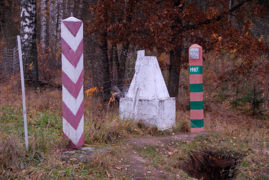
| 2 | BYLTPL | Belarus – Lithuania – Poland | Wet | 53°57’22″N 23°30’54,1″E | The tripoint is south of the Polish village of Stanowisko and can be approached from either Poland or Lithuania. The Mara river which marks the border curves at this point with a portion of Lithuania protruding towards the other 2 countries. There are 3 BM#1789, 1 in each country. Deeleman (2015) Krogh (2003) Wallis (2007) |
| 3 | LTPLRU | Lithuania – Poland – Russia | Dry | 54°21’48″N 22°47’31″E | This tripoint has added interest not only because of the proximity to the Russian exclave of Kaliningrad but that the point also forms the division between 2 Polish administrative divisions: Podlaskie Voivodeship and Warmian-Masurian Voivodeship, a quadripoint of sorts. In 2009 when I visited the old style tripoint monument, in 2010 a new granite monument was built and the area landscaped. In 2024 there are fortification to separate the RU section. Deeleman (2015) Krogh (2011) Wallis (2007) |
Tripoint Gallery
Click in the images below to access the tripoint reports

Site Navigation
In order to find your way around the site, either click on the links (text in red) or use the menus at the top and side of the pages. About leads you to the main areas of the site. The European Tripoints menu leads directly you to my visit reports whereas the Country Visits page allows you to choose which country to look at first.
Mobile User Advice
Tables display correctly when holding your mobile horizontally.
To access the links to other pages please click on the 3 horizontal dots at the bottom of the page.


For some reason, they don’t mention the Polish-occupied Vilnius region and believe Russian propaganda. Pathetic supporters of Russophiles.
LikeLike
Who are they? What is the omission you are concerned about?
LikeLike
W jaki sposób Polacy okupowali region, gdzie ponad 60% mieszkańców było Polakami, a Litwinów było kilka %? To Polacy sami siebie okupowali? A może mieli pozwolić Litwinom, by rządzili Polakami w mieście, w którym mieszkało mniej niż 5% Litwinów?
LikeLike