
The Czech Republic (Czech: Česká republika) is also known by its short-form name, Czechia. It is a country in Central Europe bordered by Germany to the west, Austria to the south, Slovakia to the east, and Poland to the northeast. The Czech Republic is a landlocked country with a hilly landscape that covers an area of 78,866 square kilometres.
The First Czechoslovak Republic, which was formed in 1918 following the collapse of the Austro-Hungarian Empire after World War I and was the only democratic state to exist in central Europe in the interwar period. During WW2 parts of the country were occupied by Germany and after the war the country became part of the Warsaw Pact behind the Iron Curtain.
Dissatisfaction with Soviet rule led to the 1968 Prague Uprising which led to a Soviet invasion. Czechoslovakia remained occupied until the 1989 Velvet Revolution, which peacefully ended communist rule and re-established democracy and a market economy. On 1 January 1993, Czechoslovakia peacefully dissolved, with its constituent states becoming the independent states of the Czech Republic and Slovakia.
Czechia is a developed country with a market economy and comprehensive social security system including free health care, education and highly developed civil liberties including a free press and democratic structures. The Czech Republic joined NATO in 1999 and the European Union (EU) in 2004. It is also a member of the OECD, the United Nations, the OSCE, and the Council of Europe.
Border Facts: Like many countries in eastern Europe the borders of Czechia have been fluid and have moved over time. The borders of the current state were established by the Treaty of Trianon (1920) with the Czech and Slovak republics forming one country. During WW2 Sudatenland was annexed by Germany but was restored in 1945. After 1946 Czechoslovakia became part of the Warsaw bloc and under the influence of the Soviet Union. Borders with the West were marked by the iron curtain with heavy fortifications. With the collapse of the Soviet Union and the independence of Czechoslovakia in 1989 the constituent parts negotiated what is referred to as the “Velvet Divorce” and in 1993 became 2 independent countries. This perhaps was inevitable with the reemergence of party politics within the constituent countries (but not across). Czechia has remained a close partner with the Slovak Republic. Both countries co-operate with Hungary and Poland in the Visegrád Group
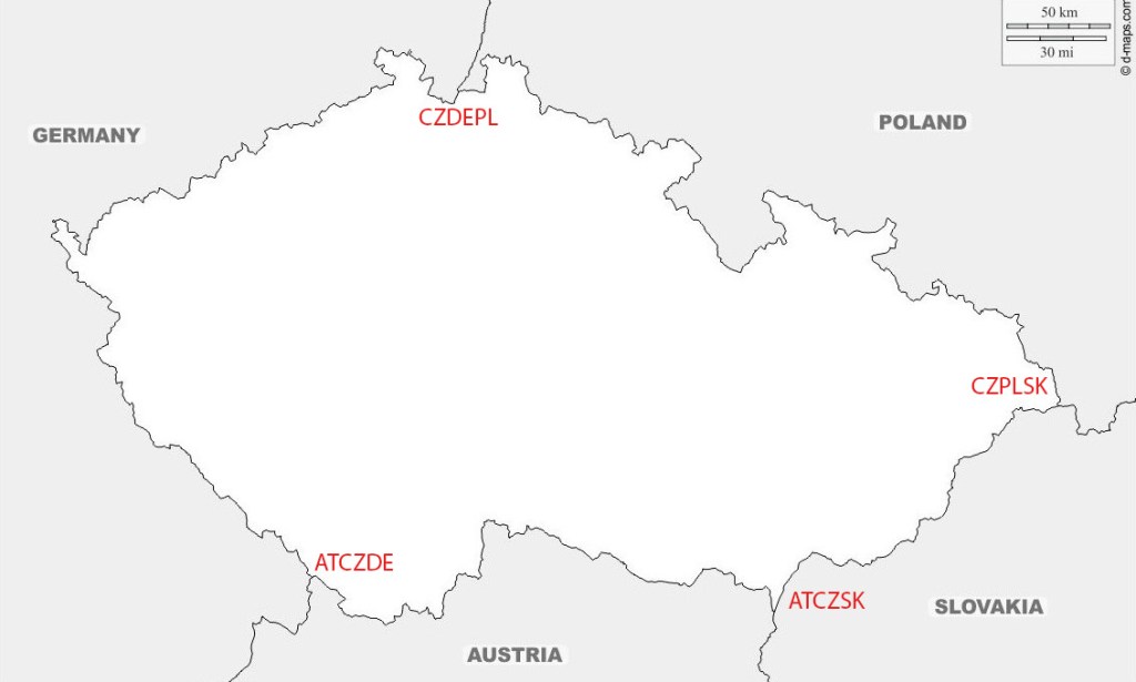
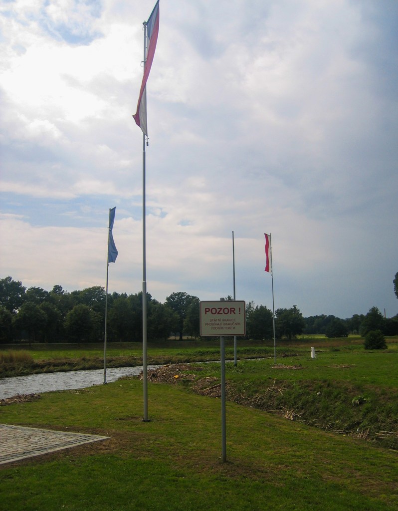
Czech Republic – Slovakia Border followed historical boundaries. Nevertheless, the border was not clearly defined at some points and, in some areas, the border cut across streets, access roads and communities that had co-existed for centuries. In such cases mutual negotiations and land transfers occurred. For example Šance went to Slovakia whereas Sidónia went to the Czech Republic. At a length of 251.8 km, the border between the Czech Republic and Slovakia is one of the newest borders in Europe. It begins in the north CZPLSK formed by the Polish, Czech and Slovak borders, near the city of Hrčava (Czech Republic). The border is fairly straight and takes a south-westerly direction up to the tripoint ATCZSK.
Czech Republic – Austria border is 466km long, it begins at the border tripoint formed by the Austrian, German and Czech borders (ATCZDE). It then turns towards the east and comes to an end at the tripoint formed by the meeting of borders between Austria, the Czech Republic and Slovakia (ATCZSK). Its demarcation crosses the rivers Inn and Morava.
This border was established in 1918, with the end of the First World War, the fall of Austro-Hungarian Empire and the creation of Czechoslovakia. During the Second World War, the region was annexed by Germany, becoming the protectorate of “Bohemia-Moravia”. The demarcation remained unchanged, with the border becoming a part of the “Iron Curtain” during the cold war. The current Austro-Czech border was established with the dissolution of Czechoslovakia on 31 December 1992 and the independence of the Czech Republic on 1 January 1993. Cross border cooperation is well established.
Czech Republic – Germany is 648km long and begins in the north-east, to the south of the German town of Wittau, with the tripoint formed by its intersection with the German-Polish and Czech-Polish borders, located on the river Neisse. The border runs alongside the ridgeline of the Ore Mountains up to the village of Mittelhammer in Bavaria. Before German reunification, this Bavarian village formed the tripoint between the FRG, GDR and Czechoslovakia. The border then turns to the south-east and passes through the forests of the Upper Palatinate and Bohemia to the tripoint with the German-Austrian and Austro-Czech borders at the edge of the Šumava National Park.
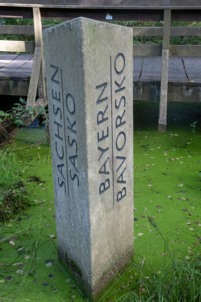
The border traces its origins to a border that separated the Austrian Empire and the German Empire during the earlier periods. During the Cold War, there were two borders in this location – one between Czechoslovakia and Saxony in the German Democratic Republic (GDR) in the north-east, and the other with Bavaria in the Federal Republic of Germany (FRG) in the south-west. The latter formed part of the Iron Curtain and was heavily fortified. This is a historical tripoint as reported here on a German language website and my 2025 visit here. The current border was established with the dissolution of Czechoslovakia on 31 December 1992 and the independence of the Czech Republic on 1 January 1993. Cross border cooperation is well established.
Czech Republic -Poland the current border between Poland and the Czech Republic was formally established on 1 January 1993, following the dissolution of Czechoslovakia. It extends 796 km, starting in the west, in the valley of Zittau at the border tripoint between Germany, the Czech Republic and Poland (CZDEPL), crossing the Sudetes mountain range (Jizera Mountains, Giant Mountains, Orlické Mountains, Hrubý Jeseník), then passing near the Czech town of Opava and north of Ostrava. The border then cuts between the twin cities of Cieszyn in Poland and Český Těšín in the Czech Republic to join the tripoint between Poland, the Czech Republic and Slovakia (CZPLSK). in the early part of the 20th Century there were territorial conflicts between the 2 countries where significant minorities of their respective countries lived.
Czech Republic Registration Plates

Czech Republic Tripoints
| number | Name | countries | coordinates | type | LINKS |
|---|---|---|---|---|---|
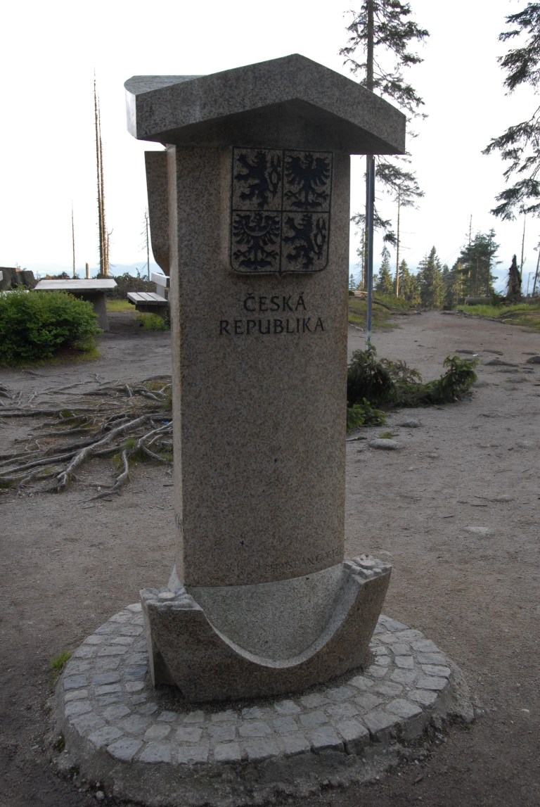
| 1 | ATCZDE | Austria – Czech Republic – Germany | 48°46’18″N 13°50’22″E | Dry | The tripoint is located in the Šumava National Park and the Bayrischer Wald nature area. Accessible from a car park near the Berggasthof Dreisessel and then walk along the Czech – German Border path to the tripoint, taking in the Bayerischer Plöckenstein on the way. The tripoint is marked by a three sided monument with national symbols on each side. Van der Giessen (2024) |
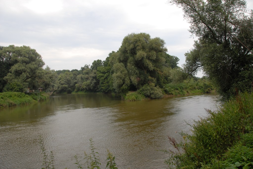
| 2 | ATCZSK | Austria – Czech Republic – Slovakia | 48°37’00″N 16°56’25″E | Wet | The tripoint is located at the confluence of the Thaya and March Rivers. It is accessible from either country. There were fishing huts on the Austrian and Slovak sides and signs and sculptures on the Slovak side. Van der Giessen (2024). |
| 3 | CZDEPL | Czech Republic – Germany – Poland | 50°52’14″N 14°49′ 24″E | Wet | The tripoint lies at the confluence between the Neisse river and the Ullersforfer Creek in the centre of the Neisse. The bordering towns are Hrádek nad Nisou (Czech Republic), Zittau (Germany) and Bogatynia (Poland). The tripoint is marked by individual grand border markers in each country plus additional monuments and flags. There are plans for a tripoint monument linking the 3 countries by a 3 way bridge. Krogh (2012) |
| 4 | CZPLSK | Czech Republic – Poland – Slovakia | 49°31’02″N 18°51’03″E | Both | The tripoint is located between Hrčava (CZ), Jaworzynka (PL) and Vyšny Koniec (SK). The actual tripoint is marked by a monument at the point 2 streams meet. It is located underneath a bridge which spans the Polish – Slovak border. The whole area has a park feel to it with walkways, signs and monuments bearing the symbols of each country. Krogh (2012) Wallis (2006) |
Tripoint Gallery
Please click on the images below to access the tripoint visit report

Historic Tripoint
Site Navigation
In order to find your way around the site, either click on the links (text in red) or use the menus at the top and side of the pages. About leads you to the main areas of the site. The European Tripoints menu leads directly you to my visit reports whereas the Country Visits page allows you to choose which country to look at first.

Mobile Users Advice
Tables display correctly when holding your mobile horizontally.
To access the links to other pages please click on the 3 horizontal dots at the bottom of the page.

References
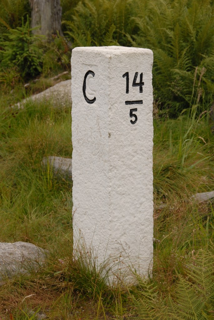
Database of Czech border markers. Details here.
