
Supplementary Information
Treaty and maps where available are listed below
| Number | Name | Countries | Treaties and Maps | |||
| 1 | AOCDCG | Angola – Democratic Republic of the Congo – Republic of the Congo | France/Portugal Accords 1884 1885 1886 and Border Treaty 1901. Ratified in 1960 and 1975 | |||
| 2 | AOCDZM | Angola – Democratic Republic of the Congo – Zambia | Anglo-Portugal and Belgium border commissions 1914. Ratified in 1960 and 1975. | |||
| 3 | AONAZM | Angola – Namibia – Zambia | First demarcated provisionally by 1931 Anglo – South Africa beacon # 9 Anglo-Portugal accord 1954. Demarcation 1964. Ratified: 1964 and 1990. | |||
| 4 | BFBJNE | Benin – Burkina Faso – Niger | ICJ BJNE decision 2005 | |||
| 5 | BFBJTG | Benin – Burkina Faso – Togo | 1912 DE/FR delimitation point #109 | |||
| 6 | BFCIGH | Burkina Faso – Ivory Coast – Ghana | Anglo/French note 1905 Map 1 | |||
| 7 | BFCIML | Burkina Faso – Ivory Coast – Mali | Map 1 | |||
| 8 | BFGHTG | Burkina Faso – Ghana – Togo | ||||
| 9 | BFMLNE | Burkina Faso – Mali – Niger | ICJ BFML judgment 1986 | |||
| 10 | BICDRW | Burundi – Democratic Republic of the Congo – Rwanda | Belgian colonial delimitation 1949 | |||
| 11 | BICDTZ | Burundi – Democratic Republic of the Congo – Tanzania | ||||
| 12 | BIRWTZ | Burundi – Rwanda – Tanzania | Fixed by Belgian ordinance of 1949 | |||
| 13 | BJNENG | Benin – Niger – Nigeria | Initially set by Anglo – French agreements 1898 & 1906. Fixed the ICJ BJNE judgment 2005 | |||
| 14 | BWNAZA | Botswana – Namibia – South Africa | Created by independence of namibia in 1990, based on colonial demarcation from 1895. | |||
| 15 | BWNAZM | Botswana – Namibia – Zambia | ||||
| 16 | BWZAZW | Botswana – South Africa – Zimbabwe | Established in 1966 based on colonial demarcation of 1898. | |||
| 17 | BWZMZW | Botswana – Zambia – Zimbabwe | ||||
| 18 | CDCFCG | Central African Republic – Democratic Republic of the Congo – Republic of the Congo | Established since independence of CD in 1960, based on BEFR agreements of 1894 & 1887. | |||
| 19 | CDCFSS | Central African Republic – Democratic Republic of the Congo – South Sudan | Established in 1899. | |||
| 20 | CDRWUG | Democratic Republic of the Congo – Rwanda – Uganda | Established by bilateral delimitations completed in 1915, inherited in 1960 by CD independence | |||
| 21 | CDSSUG | Democratic Republic of the Congo – South Sudan – Uganda | BEGB & British delimitations of 1913. | |||
| 22 | CDTZZM | Democratic Republic of the Congo – Tanzania – Zambia | Established in 1964 with the independence of ZM, based on the DEGB (1890) and BEGB (1894) accords. Map 1 | |||
| 23 | CFCGCM | Cameroon – Central African Republic – Republic of the Congo | Established in 1960, based on pre-existing colonial demarcation from 1926. | |||
| 24 | CFCMTD | Cameroon – Central African Republic – Chad | Established in 1960, based on pre-existing colonial demarcation from 1942. | |||
| 25 | CFSDSS | Central African Republic – South Sudan – Sudan | Established in July 2011, based in previous inter regional boundaries. | |||
| 26 | CFSDTD | Central African Republic – Chad – Sudan | Established in 1960. | |||
| 27 | CGCMGA | Cameroon – Gabon – Republic of the Congo | Established in 1960, based on pre-existing colonial demarcation from 1910. DEFR accord 1908. | |||
| 28 | CIGNLR | Ivory Coast – Guinea – Liberia | Established in 1960, based on pre-existing colonial demarcation from FRLR accord 1892. Possible FRLR BM. | |||
| 29 | CIGNML | Ivory Coast – Guinea – Mali | Established in 1960. Map 1 | |||
| 30 | CMGAGQ | Cameroon – Equatorial Guinea – Gabon | Established in 1960, based on pre-existing colonial demarcation from 1885. | |||
| 31 | CMNGTD | Cameroon – Chad – Nigeria | Established in 1891. FRGB 1906 & DEFR 1908 accords. FRGB Agreement. 1931. | |||
| 32 | DJERET | Djibouti – Eritrea – Ethiopia | ETIT 1908 accord. Mount Musa Ali (2028m) established by the Eritrea-Ethiopia Boundary Commission (2002). Near BM#92 DJET | |||
| 33 | DJETSO | Djibouti – Ethiopia – Somalia | FRGB 1888 accord | |||
| 34 | DZEHMA | Algeria – Morocco – Western Sahara | The DZEH boundary was delimited and demarcated by a Franco–Spanish boundary commission in the early 1900s and again from 1956–1958 and is marked by two boundary markers. One might be the TP. | |||
| 35 | DZEHMR | Algeria – Mauritania – Western Sahara | ||||
| 36 | DZLYNE | Algeria – Libya – Niger | Established in 1960. | |||
| 37 | DZLYTN | Algeria – Libya – Tunisia | Established in 1956. French mapping 1886 & 1910. DZTN pillar #1 1970 | |||
| 38 | DZMLNE | Algeria – Mali – Niger | Established in 1960. | |||
| 39 | DZMLMR | Algeria – Mali – Mauritania | Established in 1960. ESFR accord 1904. French executive decision 1911. Map 1 | |||
| 40 | EGLYSD | Egypt – Libya – Sudan | Tripoint was fixed by 1925 Italo Egyptian treaty. | |||
| 41 | ERETSD | Eritrea – Ethiopia – Sudan | GBIT 1903 commission | |||
| 42 | ETKESO | Ethiopia – Kenya – Somalia | ||||
| 43 | ETKESS | Ethiopia – Kenya – South Sudan | ||||
| 44 | ETSDSS | Ethiopia – Sudan – South Sudan | Established July 2011. | |||
| 45 | GNGWSN | Guinea – Guinea-Bissau – Senegal | Established 1958. | |||
| 46 | GNLRSL | Guinea – Liberia – Sierra Leone | Marked by cairn or pillar 1 of the 1911 Anglo – Liberian survey | |||
| 47 | GNMLSN | Guinea – Mali – Senegal | Established 1960 based on colonial administrative divisions from 1915. Map 1 | |||
| 48 | KESSUG | Kenya – South Sudan – Uganda | .Established 1962. Based on British administrative divisions from 1926. Map 1 | |||
| 49 | KETZUG | Kenya – Tanzania – Uganda | Established in 1962. Based on British administrative divisions from 1919. Map 1 | |||
| 50 | LYNETD | Chad – Libya – Niger | Established in 1960. | |||
| 51 | LYSDTD | Chad – Libya – Sudan | A tripoint since Egyptian independence in 1922. Marked with a cairn in 1923. | |||
| 52 | MLMRSN | Mali – Mauritania – Senegal | Established in 1960. Based on French administrative divisions from 1913. | |||
| 53 | MWMZTZ | Malawi – Mozambique – Tanzania | Established in 1961. Based on 1907 demarcations. | |||
| 54 | MWMZZM | Malawi – Mozambique – Zambia | The 1904 demarcation was approved by an Anglo–Portuguese agreement of October 21–November 20, 1911. | |||
| 55 | MWTZZM | Malawi – Tanzania – Zambia | Anglo–German protocol of November 11, 1898, agreed that Nankungulu was located on the watershed of the Congo basin in accordance with the terms of the agreement of July 1, 1890. Marked with a pillar #2. | |||
| 56 | MZZASZn | Mozambique – South Africa – Eswatini (north) | Established in 1961. GBPT accord of 1869. | |||
| 57 | MZZASZs | Mozambique – South Africa – Eswatini (south) | Established in 1961. GBPT accord of 1891. Map 1 | |||
| 58 | MZZAZW | Mozambique – South Africa – Zimbabwe | Established in 1961. | |||
| 59 | MZZMZW | Mozambique – Zambia – Zimbabwe | Established in 1964. GBPT accord 1891. GBPT BM#1 on the south bank 200m east. | |||
| 60 | NENGTD | Chad – Niger – Nigeria | Established in 1960. FRGB border accord 1906 . | |||
| 61 | RWTZUG | Rwanda – Tanzania – Uganda | The Anglo – German agreement of 1910 Anglo – Belgian protocol 1924 |
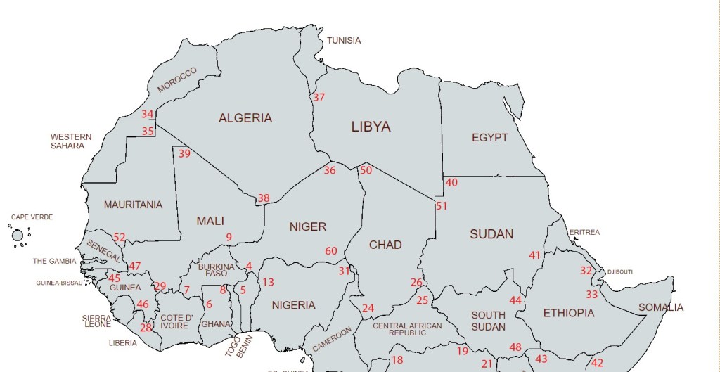
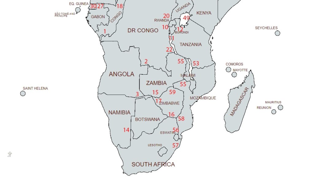
Map of African Tripoints
Northern Africa
Southern Africa
Site Navigation
In order to find your way around the site, either click on the links (text in red) or use the menus at the top of the page. About leads you to the country pages, with links to individual borders. The about menu leads you to my visit reports by country.

Mobile Users Advice
Tables display correctly when holding your mobile horizontally.
To access the links to other pages please click on the 3 horizontal dots at the bottom of the page.

References
- African tripoints. Text by Michael Donner. Edited by Jesper Nielsen Details here
