
Supplementary Information
Treaty and maps where available are listed below
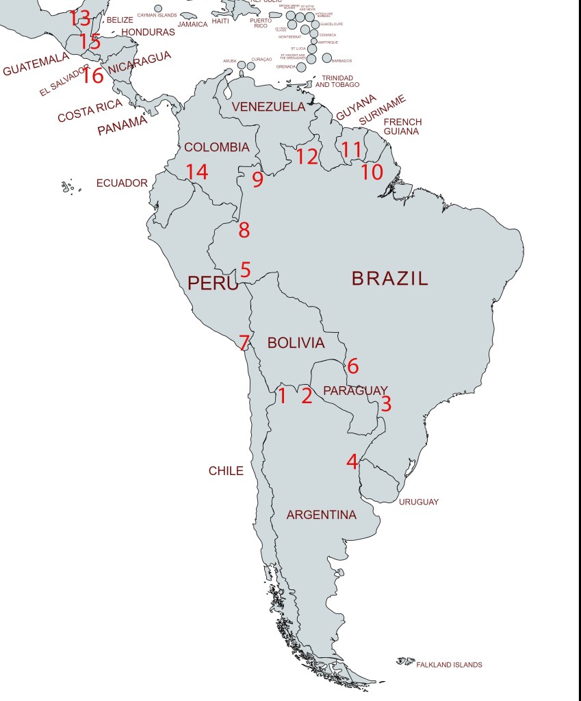
Table: Americas Tripoints
| Number | Name | Countries | Treaties and Maps |
| 1 | ARBOCL | Argentina – Boliva – Chile | Established in 1810 upon independence. ARBO accord 1889. Mount Zapaleri extinct volcano (5600m). ARBO survey 1939. Original marker iron marker 1940. Drawing. Replaced with shorter version approx. 1997. |
| 2 | ARBOPY | Argentina – Boliva – Paraguay | ARPY border accord 1876. Confirmed by BOPY arbitral award & Chaco peace treaty 1938. BOPY BM#1 and 2. The former being Hito Esmeralda as demarcated on ARBO 1940 survey map & as reiterated in ARBO protocol 1941 |
| 3 | ARBRPY | Argentina – Brazil – Paraguay | Established following PY independence from AR in 1856. |
| 4 | ARBRUY | Argentina – Brazil – Uruguay | Established following UY independence in 1830. The tripoint is located at the confluence of the Rio Uruguay with the Rio Cuareim close to the Ilha Brasileira (BR) as confirmed by the ARBR 1927 & ARUY 1961 accords. UY claims the island although the BRUY 1851 agreement allocating all islands in mouth of Cuareim to Brazil. |
| 5 | BOBRPE | Boliva – Brazil – Peru | The present tripoint position at the median junction of the rivers Yaverija & Acre was first negotiated in 1899 did not finally become effective until 1909 following an adjudication pursuant to BOPY 1902 & BOBR 1903 accords. |
| 6 | BOBRPY | Boliva – Brazil – Paraguay | Long established tripoint, established by the BOBR 1867 & BRPY 1927 delimitations and confirmed by BOBY 1938 arbitral award effectively ending the Gran Chaco war. |
| 7 | BOCLPE | Boliva – Chile – Peru | Established by Treaty of Lima 1929 aimed at solving the aftermath of the War of the Pacific, a confrontation that involved Chile against Peru and Bolivia. According to the Treaty, the Tacna-Arica Territory was divided between both countries; Tacna being awarded to Peru and with Chile retaining sovereignty over Arica. A tripoint monument replaced the one located at BM#5 COCL as the tripoint moved north following the rewriting of the border in 1929. Map 1 |
| 8 | BRCOPE | Brazil – Colombia – Peru | Established implicitly by the BRCO 1928 treaty which was based on the BRPE delimitation of 1851 and COPE agreement 1851 which placed the tripoint due west of San Antonio creek where it intersects with the thalweg of the Upper Amazon. Map 1 |
| 9 | BRCOVE | Brazil – Colombia – Venezuela | Established around 1900. The tripoint is located between the Rock of Cocuy situated on east bank & San Jose island situated near west bank. However 2 sets of BM’s erected in 1930 and 1935 respectively to demarcate the demarcation lines of the BRVE accord and the BRCO accord suggest the tripoint should be on the west bank of the river south of the island. |
| 10 | BRFRSR | Brazil – French Guiana – Suriname | Long established border point stemming from the Treaty of Breda 1667 and further defined with the independence of Brazil 1822 and Suriname in 1975. Several accords locate the tripoint at the source of the Maroni river. FRNL 1891 accord locates at source of the Lawa (with imprecise measurements). BRFR 1900 and BRNL 1906 accord followed by a BRNL commission led the building of a monument in 1962 at the intersection of the Litani River and Coulé-Coulé Creek (2n20 54w36). The Netherlands, and now Suriname, contends that the boundary follows the Marowini River to the east. Currently being negotiated by the bilateral boundary commission. |
| 11 | BRGYSR | Brazil – Guyana – Suriname | Long established border point stemming from the Treaty of Breda 1667 & Treaty of Paris 1815 and further defined with the independence of Brazil 1822 and Suriname in 1975. Disputed. The issue stems from competing claims about where the source of the Courantyne river which was to be the border between GYSR. It was either the Kutari River (1840) or the New River or Upper Courantyne (1871), This led to the New River triangle dispute. Currently GY has de facto control over the area. BRNL & BRGB delimitations & demarcations between 1906 & 1940 led to a tripoint marker (BM#132 BRGB) being erected in a gap between the Tumucumaque & Acarai ridges as per the 1940 demarcation. (1n58 56w27) |
| 12 | BRGYVE | Brazil – Guyana – Venezuela | Based on a multiple watershed divide of the Cotingo, Arabopo & Paikwa rivers near the summit of Mount Roraima (2772m). Tripoint monument established in 1931. Based on BRVE 1859 and 1926 agreements and confirmations by BRGB 1926 and GBVE in 1932. VE contests location and instead asserts the source of the Essequibo as the tripoint despite the defacto location. |
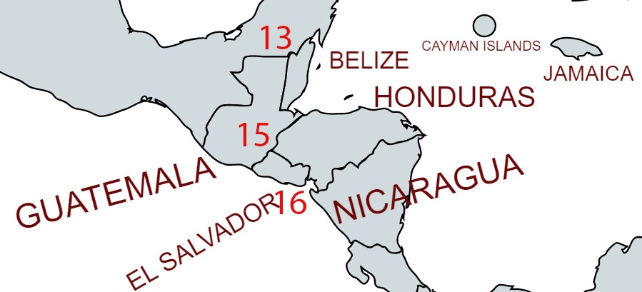
| 13 | BZGTMX | Belize – Guatemala – Mexico | Established with the independence of Belize in 1981. Based upon GTMX1882 & GBGT1859 accords and GBMX 1893 agreement. Tripoint monument established in 1899. BM#107 GTMX named Vertice Aguas Turbias. In 2002 a BZGT commission resurveyed the border the outcome of that survey has not been published in full. Accepted by MX yet has still not been finally agreed by BZ & GT given their wider border disputes. The tripoint remains at Vertice Aguas Turbias. Map 1 Map 2 Treaty 1 Treaty 2 |
| 14 | COECPE | Colombia – Ecuador – Peru | Established by the Rio Protocol in 1942. The tripoint is at the confluence of the Guepi and Putumayo rivers. BM#206 ECPE 1999 known as Hito Boca Gueppi. |
| 15 | GTHNSV | El Salvador – Guatemala – Honduras | Established initially in 1821, and subsequently by a GTHN arbitral tribunal 1933 & trilateral protocol 1936. White tripoint monument close to a nearby observation tower. 2 secondary border markers: 1) GT/SV and 2) GT/HN, no HN/SV BM’s were observed (December 2024) |
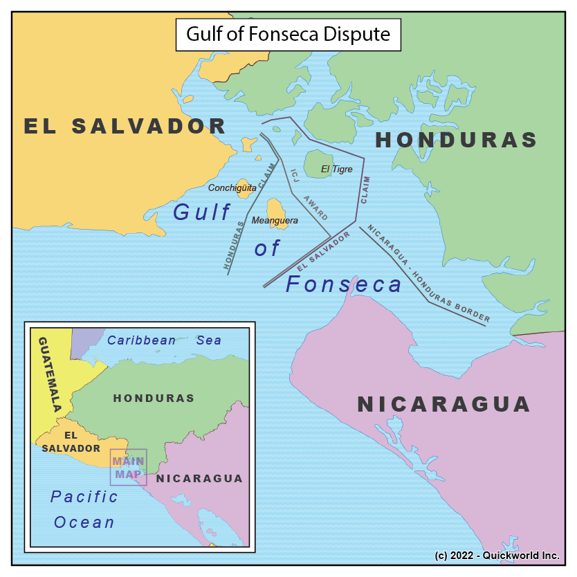
| 16 | HNNISV | El Salvador – Honduras – Nicaragua | Golfo de Fonsca is jointly shared by the 3 countries. The Gulf is divided between the 3nm strip for each country and the rest of the waters being a joint condominium. in 1992 El Salvador was awarded the islands of Meanguera and Meanguerita, while Honduras was awarded El Tigre Island. 2021 agreement confirmed the 1992 one and established a nominal NI corridor to the Pacific Ocean and further demarcations withing the Gulf. This agreement has not come into force. Cosigüina Farallones SV, a rocky set of small islands theoretically further restricts the condominium and might suggest 2 separate tripoints within the Gulf. Isla Conejo is contested between HNNI. Map 1 Map 2 |
Map of the Americas Tripoints
Central American Tripoints
Site Navigation
In order to find your way around the site, either click on the links (text in red) or use the menus at the top of the page. About leads you to the country pages, with links to individual borders. The about menu leads you to my visit reports by country.

Mobile Users Advice
Tables display correctly when holding your mobile horizontally.
To access the links to other pages please click on the 3 horizontal dots at the bottom of the page.

