
Supplementary Information
Treaty and maps where available are listed below
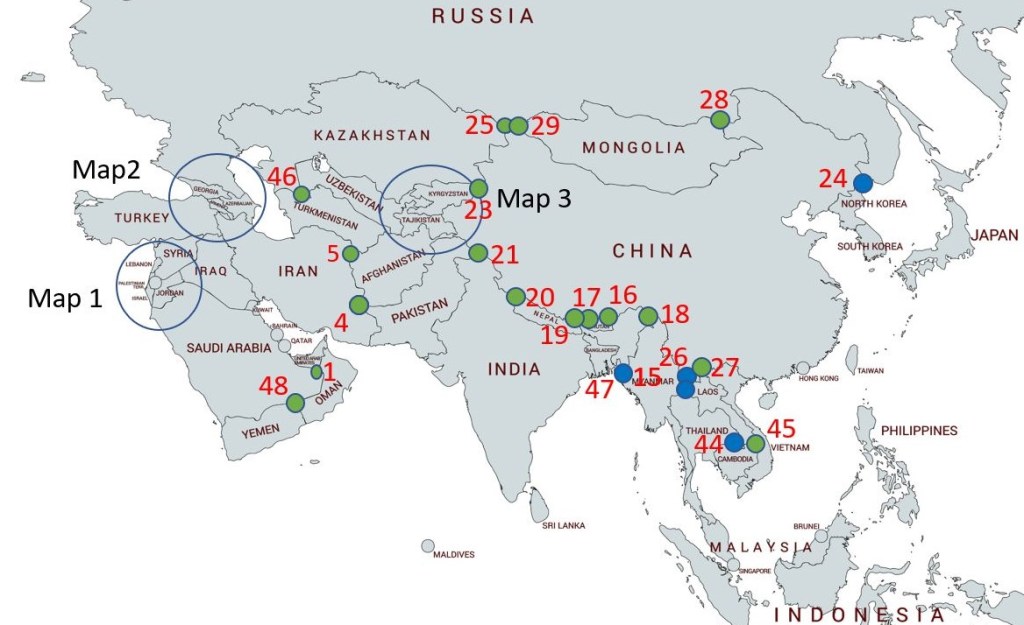
Table: Asian Tripoints
| Number | Name | Countries | Treaties and Maps |
|---|---|---|---|
| 1 | AEOMSA | Oman – Saudi Arabia – United Arab Emirates | Established in 1990 via boundary agreements based on 1920 demarcations. OMSA accord 1990. Marked in 1999 by a 5m tall brass pole. Access via new infrastructure in Oman. |
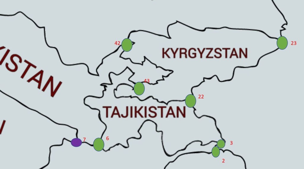
| 2 | AFCNPK | Afghanistan – China – Pakistan | Durand AFGB treaty of 1893. CNPK & AFCN treaties of the early 1960s. Unmarked. |
| 3 | AFCNTJ | Afghanistan – China – Tajikistan | |
| 4 | AFIRPK | Afghanistan – Iran – Pakistan | Established in 1919, based on 1947 borders. Possible BM#186 (1896). |
| 5 | AFIRTM | Afghanistan – Iran – Turkmenistan | Established in 1991, based on previous borders stemming back to 1885. |
| 6 | AFTJUZ | Afghanistan – Tajikistan – Uzbekistan | Established 1991, based on borders stemming from 1924. 1873 GBRU border accord relates to tripoint location. |
| 7 | AFTMUZ | Afghanistan – Turkmenistan – Uzbekistan | Established 1991, based on borders stemming from 1924. 1873 GBRU border accord relates to tripoint location. |
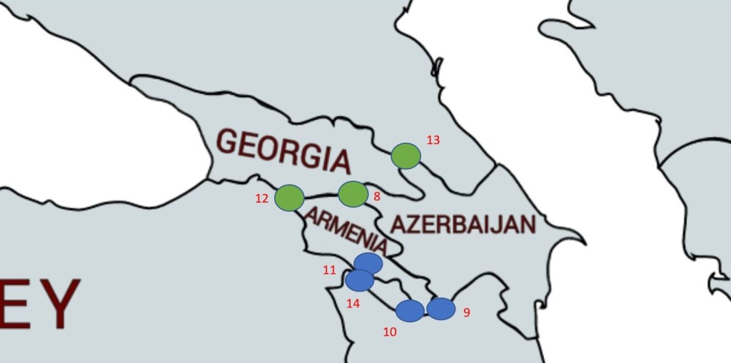
| 8 | AMAZGE | Armenia – Azerbaijan – Georgia | Established in 1991. Based on previous regional divisions and the trijunction of the trans Caucasian federation of 1917. |
| 9 | AMAZIRe | Armenia – Azerbaijan – Iran (east) | Established in 1991. Based on previous regional divisions. |
| 10 | AMAZIRw | Armenia – Azerbaijan – Iran (west) | Established in 1991. Based on previous regional divisions. |
| 11 | AMAZTR | Armenia – Azerbaijan – Turkey | Established in 1991 with the independence of Armenia, based on previous regional divisions created by the Kars Agreement 1921. Appears to be demarcated remotely by a pair of 1926 SUTR markers BM#4. |
| 12 | AMGETR | Armenia – Georgia – Turkey | Established in 1991 with the independence of Armenia, based on previous regional divisions created by the Kars Agreement 1921. The tripoint is at the secondary summit of Mount Erakatar. BM#148 SUTR 1926. |
| 13 | AZGERU | Azerbaijan – Georgia – Russia | Established with the independence of Azerbaijan in 1991 inheriting soviet administrative trijunction, Maps conflict about the precise position of the AZRU border as it converges on the tripoint. |
| 14 | AZIRTR | Azerbaijan – Iran – Turkey | Treaty of Aleksandropol in 1920 established pre existing administrative and regional borders. Established in 1991 by independence of Azerbaijan. BM#1 IRSU |
| 15 | BDINMM | Bangladesh – India – Myanmar | Established by the independence & partition of India in 1947 and Burma in 1948 (renamed Myanmar in 1989) and Bangladesh in 1971 |
| 16 | BTCNINe | Bhutan – China – India (east) | Disputed. Following CNIN war in 1962, possible location Thagla ridge just southeast of Me La pass at traditional limits of Bhutan & at the western end of LOAC. BTIN demarcation 2006 (unpublished). BTCN discussions in 2010 have not resolved the location. CN claims whole of Arunachal Pradesh state |
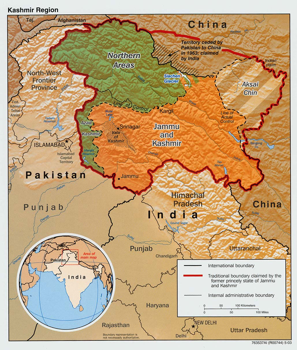
| 17 | BTCNINw | Bhutan – China – India (west) | CNGB demarcation 1890 indicated Mount Gipmochi. BTIN demarcation 2006 (unpublished). BTCN discussions in 2010 have not resolved the location. |
| 18 | CNINMM | China – India – Myanmar | Established in 1947 with the independence of India and Burma 1948. Diphu Pass is agreed by CNMM however IN believe the tripoint should be 5km further north on the watershed. Diphu Pass lies on the McMahon Line. |
| 19 | CNINNPe | China – India – Nepal (east) | GBNP accords 1890 and 1960. Jongsang peak (7463m). The Nepalese believe the tripoint is at Jhinsang Chuli (6164m) 27°50′10N 88°12′30E |
| 20 | CNINNPw | China – India – Nepal (west) | Disputed. Both India and Nepal claim the Kalapani area, currently under Indian jurisdiction. GBNP accord 1816. CNNP agreement 1960 to locate the tripoint at the watershed divide between Mapchu & Kali river & its Tinkar tributary near the Tinkar Pass . The Nepalese believe the tripoint is located at Limpiyadhura (5516m). 30°25′10 N 80°30′15 E |
| 21 | CNINPK | China – India – Pakistan | Map 1 Map 2 |
| 22 | CNKGKZ | China – Kyrgyzstan – Kazakhstan | Established with the independence of Kyrgyzstan in 1991. Based on previous administrative divisions. Map |
| 23 | CNKGTJ | China – Kyrgyzstan – Tajikistan | Established with the independence of Kyrgyzstan in 1991. Based on previous administrative divisions. Map |
| 24 | CNKPRU | China – North Korea – Russia | Several treaties since 1985. Joint Border Treaty 2002. There is no CNKPRU tripoint here, but a CNKPKPRU tripoint where the Korean border and the Russian border meet the joint Chinese-Korean border 2). There is also a CNKPRU triline where the common CNKP river border meets the Russian part of the river. Eventually there is also a CNCNKPRU tripoint border where Chinese land border meets the CNKP border and the RU border. Map 1 |
| 25 | CNKZRU | China – Kazakhstan – Russia | Established since Kazakh independence in 1991. Based on previous administrative divisions. |
| 26 | CNLAMM | China – Laos – Myanmar | Established in 1953. |
| 27 | CNLAVN | China – Laos – Vietnam | Based on CNFR 1895 accord & LAVN agreements dating from 17th century. Established in in 1945 by independence of Vietnam & Laos & received its first tripartite marker in 2005 and full agreement in 2006. |
| 28 | CNMNRUe | China – Mongolia – Russia (east) | Established by Mongolian declaration of independence in 1911. Based on previous administrative divisions. Recognized by China with CNMN accord of 1962 & demarcation of 1964. Marker is elevated above salt marsh on stilts. |
| 29 | CNMNRUw | China – Mongolia – Russia (west) | Established by Mongolian declaration of independence in 1911. CNMN accord of 1962 which was followed by a general demarcation. Tripoint not marked. |
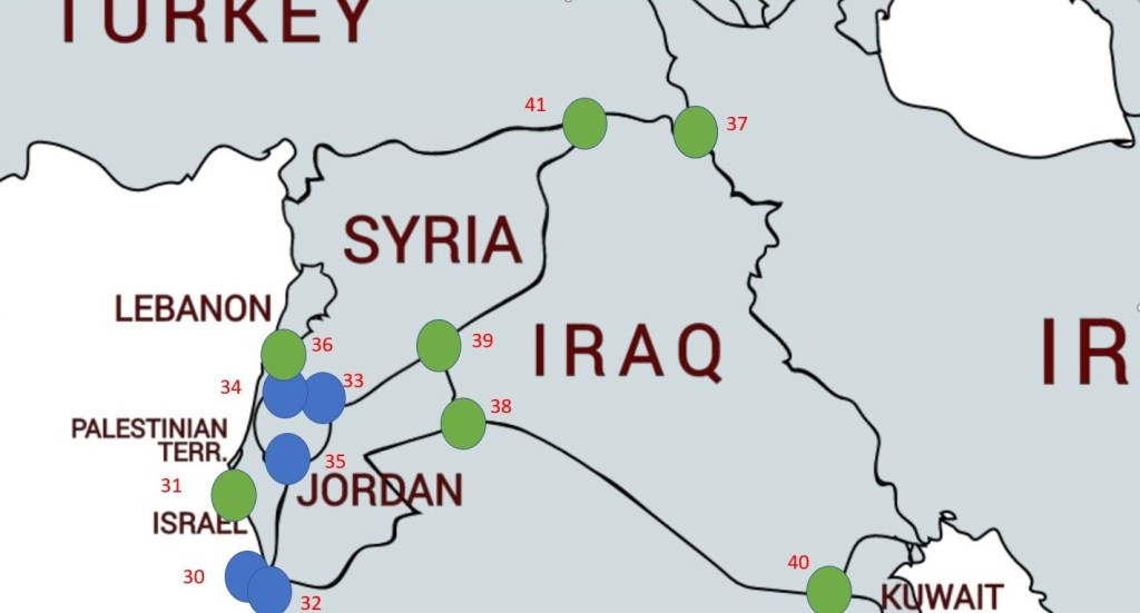
| 30 | EGILJO | Egypt – Israel – Jordan | Established by the since independence of Egypt in 1922 initially and the independence of Israel in 1948 |
| 31 | EGILPS | Egypt – Israel – Palestine | Established by the since independence of Egypt in 1922 initially and the independence of Israel in 1948 |
| 32 | EGJOSA | Egypt – Jordan – Saudi Arabia | Established by the since independence of Egypt in 1922 initially and the independence of Jordan in 1946 |
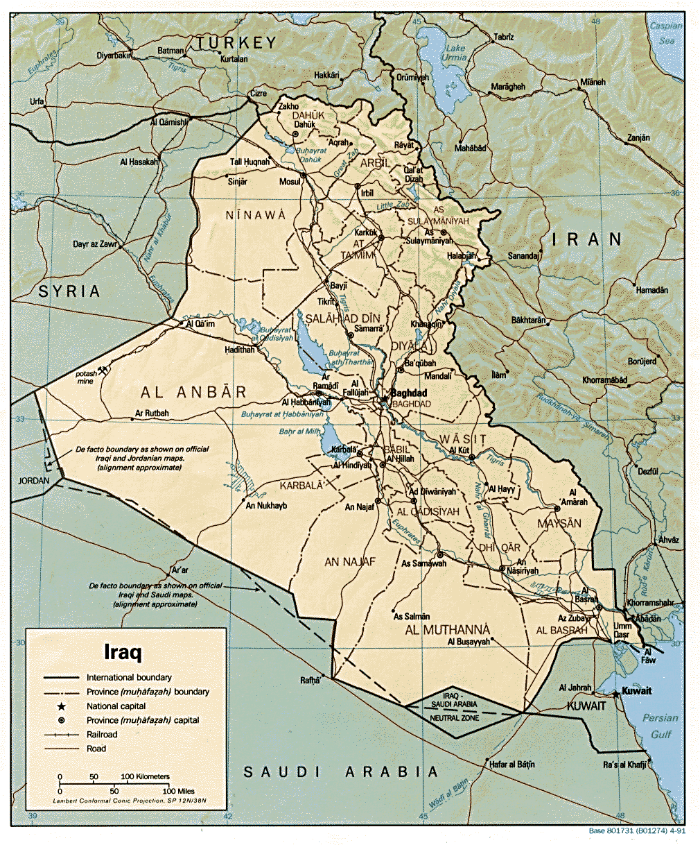
| 33 | ILJOSY | Israel – Jordan – Syria | Established by the independence of Jordan in 1946 and independence of Israel in 1948. Based on the Sykes–Picot Agreement 1916. UN buffer zone in place currently. |
| 34 | ILJOPSn | Israel – Jordan – Palestine (north) | Established by the since independence of Jordon in 1946 initially and the independence of Israel in 1948. Based on the Sykes–Picot Agreement 1916. |
| 35 | ILJOPSs | Israel – Jordan – Palestine (south) | Established by the independence of Jordon in 1946 initially and the independence of Israel in 1948. Based on the Sykes–Picot Agreement 1916. |
| 36 | ILLBSY | Israel – Lebanon – Syria | Established by the independence of Israel in 1948. Based on the Sykes–Picot Agreement 1916. Israel military conquests has pushed the de facto 30 km tripoint northward |
| 37 | IQIRTR | Iran – Iraq – Turkey | Established by the independence of Iraq in 1932. The tripoint is marked by BM#125/12 (1925) at the source of the Hajji Bak river. |
| 38 | IQJOSA | Iraq – Jordan – Saudi Arabia | Established by the independence of Iraq in 1932 and Jordon in 1946. The initial IQSA accord 1922 and confirmation by GBIQ agreement 1932 superseded by IQSA accord 1984 about 12km south westward. Map 1 |
| 39 | IQJOSY | Iraq – Jordan – Syria | Established by the independence of Iraq in 1932 and Jordon and Syria in 1946. Based on the Sykes–Picot Agreement 1916. Not clearly delimited & agreed until GBIQ Accord 1932. |
| 40 | IQKWSA | Iraq – Kuwait – Saudi Arabia | Established by the independence of Iraq in 1932 and Kuwait in 1961. Marked by IQKW BM#1 1993 & later IQSA BM#1 |
| 41 | IQSYTR | Iraq – Syria – Turkey | Established initially by the Conference of London 1920. Adjudicated in 1925 & agreed in 1926. |
| 42 | KGKZUZ | Kyrgyzstan – Kazakhstan – Uzbekistan | Established in 1991 based on previous Soviet demarcations. |
| 43 | KGTJUZ | Kyrgyzstan – Tajikistan – Uzbekistan | Established in 1991 based on previous Soviet demarcations. |
| 44 | KHLATH | Cambodia – Laos – Thailand | Established in 1953 by independence of Cambodia & Laos. Based on previous FRTH demarcations. |
| 45 | KHLAVN | Cambodia – Laos – Vietnam | Established in 1953 by independence of Cambodia & Laos. Based on previous FRTH demarcations. |
| 46 | KZTMUZ | Kazakhstan – Turkmenistan – Uzbekistan | Established in 1991 based on previous Soviet demarcations in 1936. |
| 47 | LAMMTH | Laos – Myanmar – Thailand | Established by the independence of Laos in 1953. Based on prior FRGB accord 1896 and FRTH accord 1893. |
| 48 | OMSAYE | Oman – Saudi Arabia – Yemen | Established in 1918 and by 3 successive bilateral agreements concluded between 1990 & 2000. Monument built in 2005. |
Maps of Asian Tripoints


Site Navigation
In order to find your way around the site, either click on the links (text in red) or use the menus at the top of the page. About leads you to the country pages, with links to individual borders. The about menu leads you to my visit reports by country.
Mobile Advice
Tables display correctly when holding your mobile horizontally.
To access the links to other pages please click on the 3 horizontal dots at the bottom of the page.

