
Additional Information
Treaty and maps where available are listed below
Table: European Tripoints
| Number | Name | Countries | Treaties and Maps | |
| 1 | ADESFRe | Andorra – France – Spain (East) | A condominium trijunction almost continuously since 1278. Marked by original 1868 ESFR BM#427, Became an international tripoint after the adoption of the 1993 Andorran Constitution and admittance to the UN. | |
| 2 | ADESFRw | Andorra – France – Spain (West) | A condominium trijunction almost continuously since 1278. Became an international tripoint after the adoption of the 1993 Andorran Constitution and admittance to the UN. ESFR treaty 1862 located the tripoint on Pic de Baiau and not its current location. | |
| 3 | ALGRMK | Albania – Greece – Macedonia | Established in 1912 following a secret GRRS demarcation and Albanian independence. Confirmed by the Conference of London 1913 and following Greek withdrawal from AL in 1923 and subsequent ratification in 1926. Macedonia became independent in 1991. | |
| 4 | ALKVME | Albania – Kosovo – Montenegro | Established in 2006. Based on previous administrative YU borders from1945. | |
| 5 | ALKVMK | Albania – Kosovo – Macedonia | Established in 2006. Based on previous administrative YU borders from1945. New tripoint monument in 2008. | |
| 6 | ATCHDE | Austria – Germany – Switzerland | Established partially with the Bavarian cession of Vorarlberg to Austria in 1814 and the creation of the German Confederation in 1871. There has never been any agreement between the three parties involved on how to “divide” the lake. CH regards the mid-line between DE/CH as the natural borderline, Austria’s opinion is that the Eastern part of the lake should be governed by all states, and Germany’s point of view is not really known. | |
| 7 | ATCHIT | Austria – Italy – Switzerland | Established in 1919 by the cession of south Tirol from Austria to Italy. CHIT demarcations 1920 and 1924. Tripoint marked by a border marker placed flat on top of a rock. | |
| 8 | ATCHLIn | Austria – Liechtenstein – Switzerland (north) | A long established tripoint dating back to 1434. ATCH & CHLI agreements locate the tripoint at the intersection of the Alpenrhein river with the border demarcated by the border markers on each side of the Rhine BM#135 in AT and BM#136 in CH. BM#136 in CH is the tripoint marker. | |
| 9 | ATCHLIs | Austria – Liechtenstein – Switzerland (south) | A long established tripoint dating back to 1434. The tripoint is located on the summit of the Naafkopf, a mountain in the Rätikon Alps. The tripoint is marked by a large wooden cross on a brick base that extends in three direction | |
| 10 | ATCZDE | Austria – Czech Republic – Germany | A long established tripoint dating back to 1765 and the border between Austria with Bavaria & Bohemia. Dismemberment of Austria Hungary in 1919 impacted on this point. Located on the southern flank of the Dreisesselberg on the Boehmerwald ridge near the Ploeckenstein summit. | |
| 11 | ATCZSK | Austria – Czech Republic – Slovakia | A long established boundary dating back to 14th Century. Established in 1991 by breakup of Czechoslovakia. Based on 1928 Austria Czechoslovakia agreement. | |
| 12 | ATHUSI | Austria – Hungary – Slovenia | Established in 1921 by the transfer of Burgenland from Hungary to Austria per treaties of saint Germain & Trianon whose dates are recorded on monument. | |
| 13 | ATHUSK | Austria – Hungary – Slovakia | Established in 1921 by the transfer of Burgenland from Hungary. Following WWII there was a ceding of a small additional territory from Hungary to Czechoslovakia moving the tripoint toward the SE. | |
| 14 | ATITSI | Austria – Italy – Slovenia | Established in 1919 by treaty of St Germain. Located on summit of Mount Pec (1509m) at the junction of the Carnic & Julian alps marking the ancient Germanic-Italo-Slavic triple frontier. Re-established with the independence of Slovenia (from YU) in 1991. | |
| 15 | BAHRME | Bosnia and Herzegonia – Croatia – Montenegro | Originally a Yugoslav federal trijunction created in 1945, altered by the independence of Bosnia Herzegovina in 1992 and Montenegro in 2006. BAHR 1999 accord stating it has been agreed & demarcated by a pyramid. Unclear if that has happened. | |
| 16 | BAHRRS | Bosnia and Herzegonia – Croatia – Serbia | Originally a Yugoslav federal trijunction created in 1945, altered by the independence of Bosnia Herzegovina in 1992 and Montenegro in 2006. Location agreed and possibly marked BAHR accord 1999 at the thalweg of the Sava opposite the centre of mouth of the Lukavac brook. | |
| 17 | BAMERS | Bosnia and Herzegonia – Montenegro – Serbia | Originally a Yugoslav federal trijunction created in 1945, altered through the breakup of Serbia & Montenegro in 2006. Agreement signed in 2019. | |
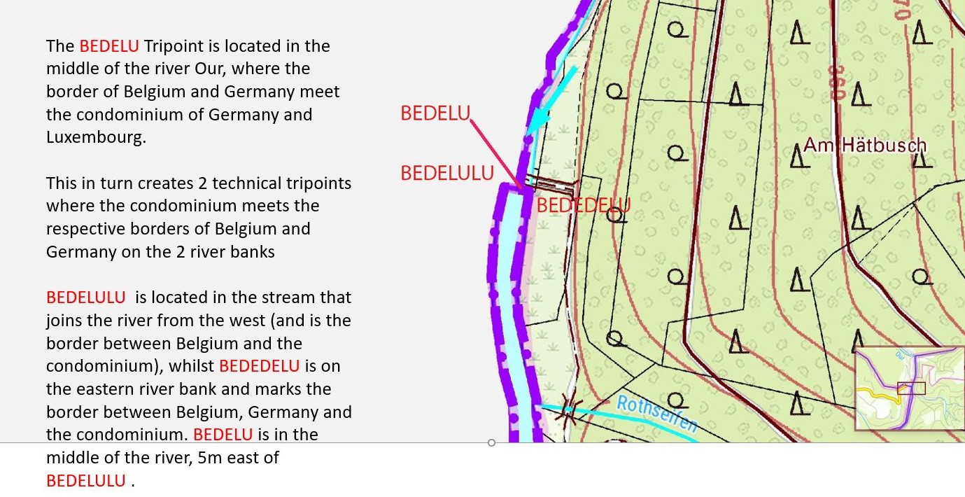
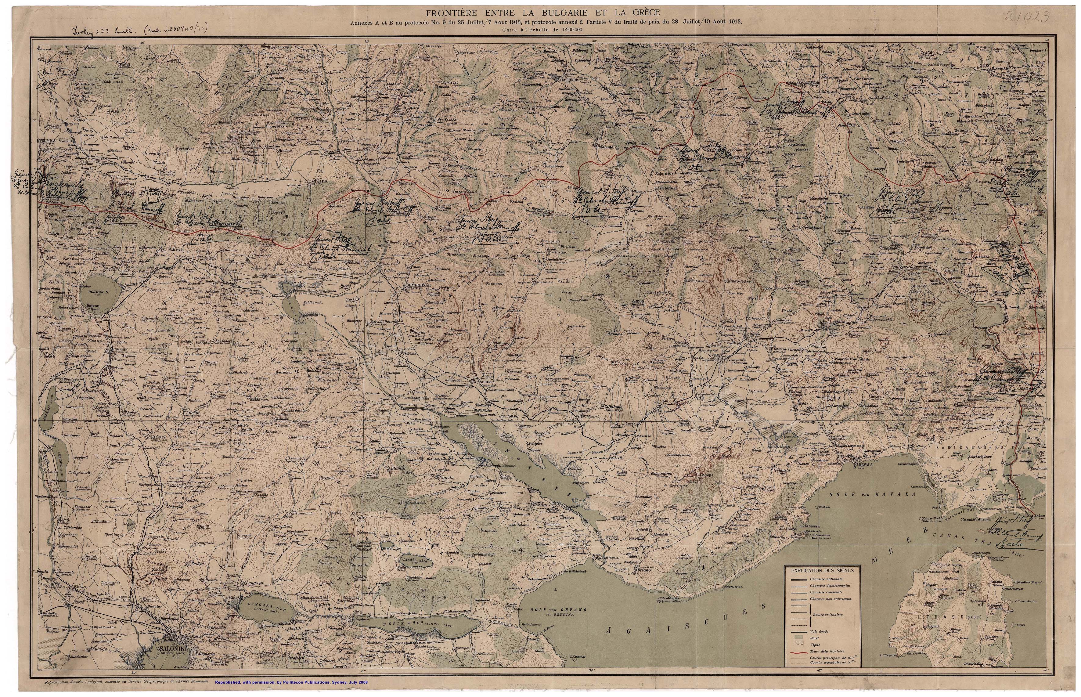
| 18 | BEDELU | Belgium – Germany – Luxembourg | Established by the unification of Germany in 1871 and the independence of Luxembourg from Belgium in 1839. DELU 1984 accord. A triline exists due to the DELU condominium of the Our river south of the BE border which is marked by the Ribbach creek. BE, DE and LU BM’s on each side. Map 1 Map 2 | |
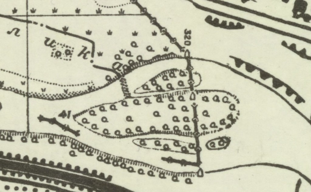
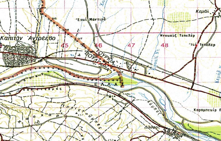
| 19 | BEDENL | Belgium – Germany – Netherlands | Long established boundary point. Established through the independence of Belgium from the Netherlands in 1830 and German unification on 1871. Between 1816 to 1921 it was a quadripoint with the creation of Neutral Moresnet by the Congress of Vienna as a condominium to balance power in Europe after the Napoleonic Wars. The territory was jointly administered by the Kingdom of the Netherlands and the Kingdom of Prussia. Marked by an octangular monument. | |
| 20 | BEFRLU | Belgium – France – Luxembourg | Established through the separation of Belgium from the Netherlands in 1839. Situated at the confluence of the Chiers river & Bruehl creek. | |
| 21 | BGGRMK | Bulgaria – Greece – Macedonia | Established with the treaty of Neuilly sur Seine 1919. Demarcated in 1913 unilaterally by Bulgaria which led to a strange saliant border configuration to allow the respective borders to meet at the summit. Many BM’s on either side of the corridor. Map 1 Map2 Map 3 | |
| 22 | BGGRTR | Bulgaria – Greece – Turkey | Established with the Treaty of Lausanne 1923 established the tripoint in the Maritsa river, alterations in the course led to a creation of an island which was divided between BGGR in 1956. The tripoint was located here following a further river alignment between 1972 and 1975. Map 1 Map 2 Map 3 | |
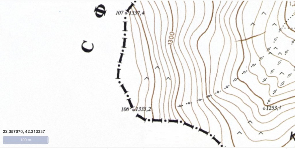
| 23 | BGMKRS | Bulgaria – Macedonia – Serbia | Originally a Yugoslav federal trijunction created in 1945, altered through the independence of Macedonia in 1991. MKRS agreement 2001 BM#106 BGYU replaced with a tripoint monument. The tripoint is located on Shulep Kamak Peak (1337m) and marked by a monument with Cyrillic lettering on all sides. Map 1 | |
| 24 | BGRORS | Bulgaria – Romania – Serbia | Long established boundary point. Altered through the independence of Romania in 1878 and Bulgaria in 1908. Defined by Treaty of Neuilly 1919 as the confluence at the thalweg of the Danube river with the Timok river. Marked with a tripoint RO monument. | |
| 25 | BYLTLV | Belarus – Lithuania- Latvia | Established through the independence of Lithuania (1990) Latvia (1991) and Belarus (1991), previously a soviet internal demarcation. The tripoint consists of a 6 meter neutral square near Liudevinova lake. | |
| 26 | BYLTPL | Belarus – Lithuania – Poland | Long established boundary point. Established through Lithuanian independence in 1990. Located in the Mara river. BM#1789 in each country. | |
| 27 | BYLVRU | Belarus – Latvia – Russia | Established through the independence of Belarus in 1991, previously a soviet internal demarcation. Located at the intersection of the Neverica and Zilup rivers | |
| 28 | BYPLUA | Belarus – Poland – Ukraine | Established through the break up of the Soviet Union in 1991. The tripoint is located at the intersection of a line running through the middle of the Bug River (Western Bug) with a line constituting an extension of the southern edge of the Mościcki Canal. There are 3 TP monuments, | |
| 29 | BYRUUA | Belarus – Russia – Ukraine | Established through the collapse of the Soviet Union in 1991. Previous internal Soviet borders. An impressive monument “The Three Sisters” is built on a mound of friendship “kurgan druzhby“. In 2024 UA is preparing to demolish it for obvious reasons. | |
| 30 | CHDEFR | France – Germany – Switzerland | Established through the Treaty of Paris 1814. Situated in the Rhine where the East- West DECH border meets the North – South DEFR border. NW of an impressive rocket shaped tripoint monument and south of a pedestrian bridge. 2 BM’s CHDE on the eastern bank. | |
| 31 | CHFRIT | France – Italy – Switzerland | Established by 1815 congress of Vienna. The tripoint is located at Pointes Supérieures de Pré de Bar (3658m), on the ridge that leads east (100m) to the summit of Mount Dolent (3749m). | |
| 32 | CZDEPL | Czech Republic – Germany – Poland | Located here through the Potsdam Conference that shifted the borders of Poland west and subsequent breakup of Czechoslovakia in 1993. The tripoint lies at the confluence between the Neisse river and the Ullersforfer Creek in the centre of the Neisse. | |
| 33 | CZPLSK | Czech Republic – Poland – Slovakia | Established through the breakup of Czechoslovakia in 1993. Originally a border stemming from the division of Teschen Silesia between Czech Moravia and Poland in 1920. Marked in a dry creek below a bridge. Other tripoint monuments are nearby. | |
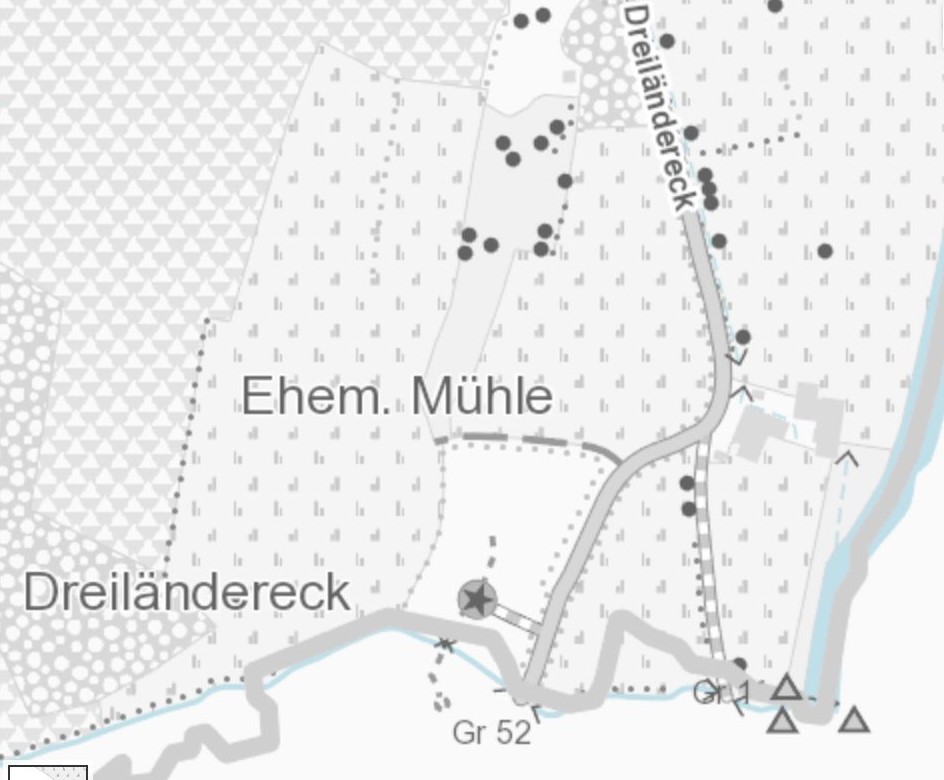
| 34 | DEFRLU | France – Germany – Luxembourg | Originally a border since the creation of the Prussian – Dutch Condominium in 1815. Revised politically by the independence of Belgium from the Netherlands in 1830 & of Luxembourg from Belgium in 1839 as well as by the unification of Germany in 1871. The borders at this triline (not tripoint) are complicated because of the condominium arrangements regarding the shared ownership of the Moselle between Germany and Luxembourg. | |
| 35 | EELVRU | Estonia – Latvia – Russia | Established through the collapse of the Soviet Union in 1991. Previous internal Soviet borders. Previous internal Soviet borders. Revised politically with the independence of Estonia and Latvia. Located in the Pededze river, 90m north of its confluence with the Laikupe river where the RULV border intersects. EE BM’s. | |
| 36 | FINORU | Finland – Norway – Russia | Established in 1944 with the transfer of the Petsamo district from Finland to the Soviet Union. A further amendment arose when in 1947, Finland sold the 169 square kilometer Jäniskoski area with its hydroelectric plant to SU, in exchange for Soviet-confiscated German investments in Finland. Marked by a cairn. White pyramid added post 1991 with names of countries. Map 1 | |
| 37 | FINOSE | Finland – Norway – Sweden | Established by the independence of Norway from Sweden in 1905 and the independence of Finland from Russia in 1917. A monument of stones was erected on the site by Russia in 1897. The Swedish could not agree on a boundary commission with the Norwegians and did not contribute their stone until 1901. On the Norwegian side it says 1897 (from the previous Russian inscription) and Swedish side it says 1901, which is the year when the top stone was erected.The current tripoint monument was built in 1926 and was originally beige, conical frustum made of concrete, located about 10 metres out in Lake Goldajärvi on an artificial island. | |
| 38 | HRHURS | Croatia – Hungary – Serbia | Established with the independence of Croatia in 1991. 2 possible positions – in the thalweg of the Danube (current de facto situation) as promoted by RS or 6 km further east to the canal beside HUYU BM#465 as promoted by HR. | |
| 39 | HRHUSI | Croatia – Hungary – Slovenia | Established since independence of Slovenia in 1991. Following arbitration the tripoint is located at the confluence of the Mura river at its thalweg junction with the Kerka river (SI position) currently the HRHU border located between BM#a653 & BM#b1. Croatia however (using cadastre maps) locates the tripoint at BM#a645 HUYU In the border area, the river Mura meanders, occasionally floods, and has over time naturally modified its course. The border, however, has customarily remained as previously determined; thus, the border today does not strictly follow the present-day river’s course. Slovenia has proposed that the border follow the present-day river, but Croatia has rejected this. Map 1 | |
| 40 | HURORS | Hungary – Romania – Serbia | Established by the Treaty of Trianon 1920, current position confirmed by RORS protocol with the Triplex Confinium monument BM#1 of both HURO & ROYU series. | |
| 41 | HUROUA | Hungary – Romania – Ukraine | Established by the Treaty of Trianon 1920. Established in current position by international commission in 1921. Location established following the transfer of Carpathian Rus from Czechoslovakia to the Soviet Union in 1945 & by the independence of Ukraine in 1991. Located in the Tur river. 3 Tripoint markers, one in each country. | |
| 42 | HUSKUA | Hungary – Slovakia – Ukraine | Established by the Treaty of Trianon 1920, and following land exchange between CS and SU the tripoint is located in the Tisza river. There are BM#375 SKUA and 3 tripoint markers one in each country with SK the most easy to access. | |
| 43 | KVMERS | Kosovo – Montenegro – Serbia | The tripoint is located at the summit of Beleg mountain (2142m), a second summit of Mokra Gora. There is a sculpture on the summit but no tripoint marker given RS no recognition of KV. | |
| 44 | KVMKRS | Kosovo – Macedonia – Serbia | ||
| 45 | LTPLRU | Lithuania – Poland – Russia | Established by the Treaty of Versailles in 1919 and then the Potsdam conference in 1945. Initially East Prussia and now the Russian exclave of Kaliningrad. Initially marked with BM#1987 BM#PLSU and then a marble tripoint monument in 2010. | |
| 46 | MDROUAn | Moldova – Romania – Ukraine (north) | Following the transfer of the Moldovian SSR in 1945 from Romania to the Soviet Union and the collapse of the USSR and independence of Ukraine in 1991 the tripoint was established in the Prut river. Demarcated in alignment with BM#001 and #002 MDUA markers in 2004. | |
| 47 | MDROUAs | Moldova – Romania – Ukraine (south) | Following the transfer of the Moldovian SSR in 1945 from Romania to the Soviet Union and the collapse of the USSR and independence of Ukraine in 1991 the tripoint was established at the confluence of the Prut and Danube rivers. | |
| 48 | PLSKUA | Poland – Slovakia – Ukraine | Established following the break up of Czechoslovakia in 1993. Located on the summit of Kremenec (1221m). Marked by a 3 sided marble monument with national symbols inscribed on it. |
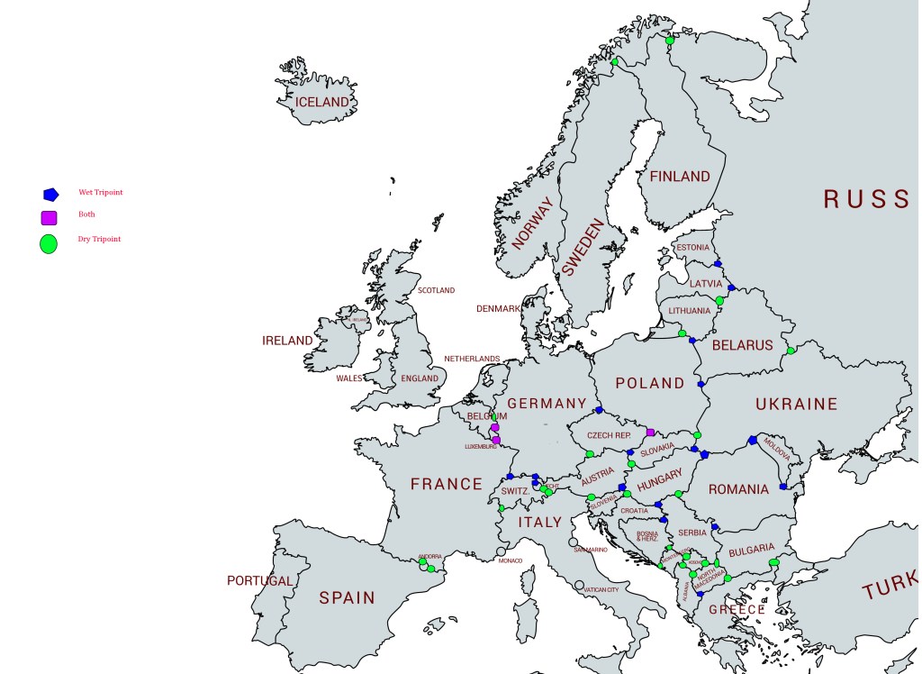
Map of European Tripoints
Site Navigation
In order to find your way around the site, either click on the links (text in red) or use the menus at the top of the page. About leads you to the country pages, with links to individual borders. The about menu leads you to my visit reports by country.

Mobile Users Advice
Tables display correctly when holding your mobile horizontally.
To access the links to other pages please click on the 3 horizontal dots at the bottom of the page.

