
The Berlin Wall (German: Berliner Mauer), was a guarded concrete barrier that divided Berlin from 1961 to 1989. It encircled West Berlin, separating it from East German territory. Construction of the wall was commenced by the German Democratic Republic (GDR, East Germany) on 13 August 1961. The Wall cut off West Berlin from surrounding East Germany, including East Berlin. It included guard towers placed along large concrete walls, accompanied by a wide area (later known as the “death strip”) that contained anti-vehicle trenches, beds of nails and other defenses.

Berlin was divided into occupation zones, the allied and the Soviet. Initially travel between the east and western zones was uncontrolled, however increasingly restrictions were placed on movement, especially after the erection of the inner German border. In 1955, the Soviets gave East Germany authority over civilian movement in Berlin, passing control to a regime not recognized in the West. Initially, East Germany granted “visits” to allow its residents access to West Germany. However, following the defection of large numbers of East Germans (known as Republikflucht) under this regime, the new East German state legally restricted virtually all travel to the West in 1956.
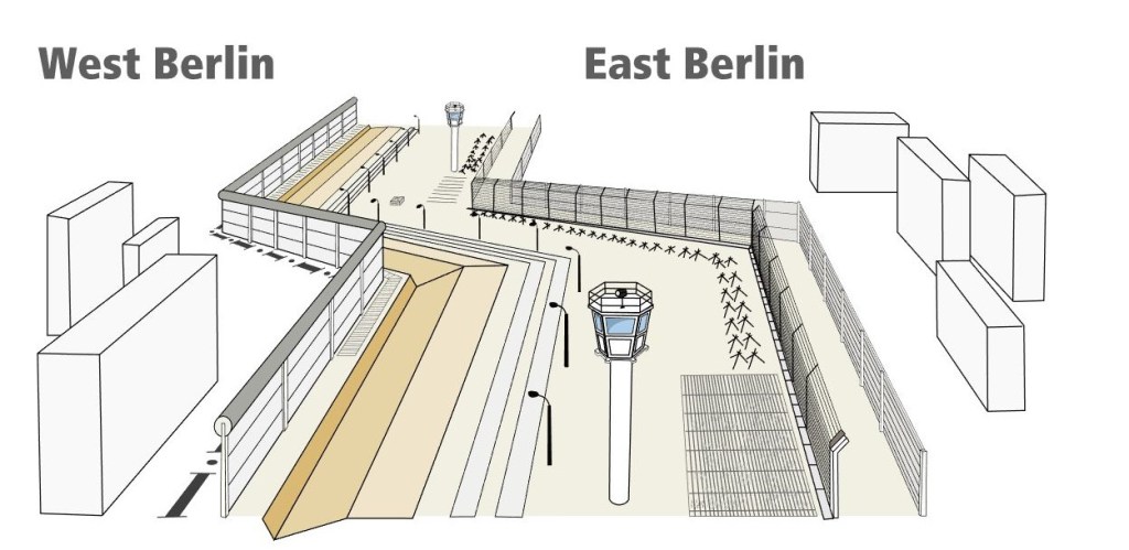
The Berlin Wall was more than 140 kilometres long. In June 1962, a second, parallel fence, also known as a “hinterland” wall (inner wall), was built some 100 metres farther into East German territory. The houses contained between the wall and fences were razed and the inhabitants relocated, thus establishing what later became known as the death strip. The death strip was covered with raked sand or gravel, rendering footprints easy to notice, easing the detection of trespassers and also enabling officers to see which guards had neglected their task; it offered no cover; and, most importantly, it offered clear fields of fire for the Wall guards.
Through the years, the Berlin Wall evolved through four versions:
Wire fence and concrete block wall (1961)
Improved wire fence (1962–1965)
Improved concrete wall (1965–1975)
Grenzmauer 75 (Border Wall 75) (1975–1989)
The “fourth-generation Wall”, known officially as “Stützwandelement UL 12.11” (retaining wall element UL 12.11), was the final and most sophisticated version of the Wall. Begun in 1975 and completed about 1980, it was constructed from 45,000 separate sections of reinforced concrete, each 3.6 metres high and 1.2 metres wide, and cost DDM 16,155,000 or about US$3,638,000. The concrete provisions added to this version of the Wall were done to prevent escapees from driving their cars through the barricades. The top of the wall was lined with a smooth pipe, intended to make it more difficult to scale. The Wall was reinforced by mesh fencing, signal fencing, anti-vehicle trenches, barbed wire, dogs on long lines, “beds of nails” (also known as “Stalin’s Carpet”) under balconies hanging over the “death strip”, over 116 watchtowers, and 20 bunkers with hundreds of guards.
As was the case with the inner German border, an unfortified strip of Eastern territory was left outside the wall. Often this strip was unmarked and in some cases was utilised as pavements in the centre of Berlin and allotments elsewhere. Graffiti was a feature of the western side of the wall.
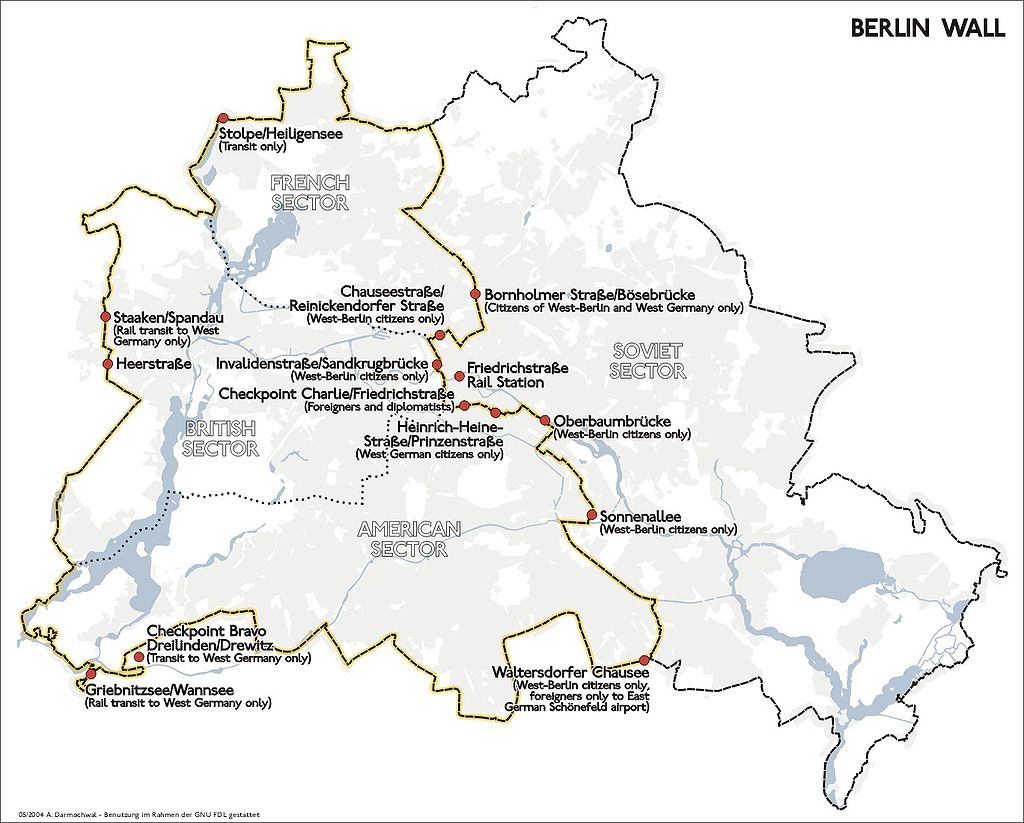
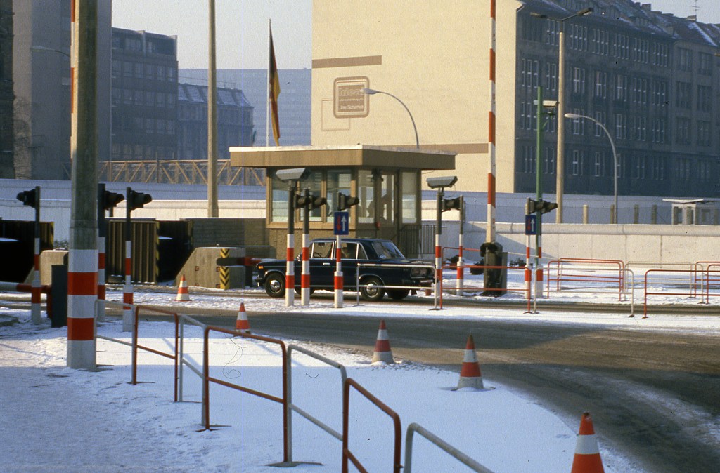
There were nine border crossings between East and West Berlin. These allowed visits by West Berliners, other West Germans, Western foreigners and Allied personnel into East Berlin, as well as visits by GDR citizens and citizens of other socialist countries into West Berlin, provided that they held the necessary permits. These crossings were restricted according to which nationality was allowed to use it (East Germans, West Germans, West Berliners, other countries). The best known was the vehicle and pedestrian checkpoint at the corner of Friedrichstraße and Zimmerstraße (Checkpoint Charlie), which was restricted to Allied personnel and foreigners.


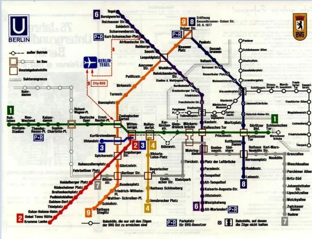
In East Berlin walking towards the famous Friedrichstrasse Station. Despite the station being wholly located in East Berlin, all of the station’s underground facilities, namely the S-Bahn platform of the North-South tunnel and the underground station, were only accessible for passengers from the western sectors as a transfer station, or to access the border crossing at the ground level. Note the white barriers on top of the bridge. These were to prevent access to the west bound tracks but also to stop passengers looking into East Berlin.
It was possible therefore to cross the wall and not enter the DDR by transferring to another service at Friedrichstrasse, as the platforms were separated from East Berlin and the transport network in the east. The map below shows the connections and closed stations.
Several other border crossings existed between West Berlin and surrounding East Germany. These could be used for transit between West Germany and West Berlin, for visits by West Berliners into East Germany, for transit into countries neighbouring East Germany (Poland, Czechoslovakia, Denmark), and for visits by East Germans into West Berlin carrying a permit. After the 1972 agreements, new crossings were opened to allow West Berlin waste to be transported into East German dumps, as well as some crossings for access to West Berlin’s exclaves (see Steinstücken below).
Four autobahns connected West Berlin to West Germany, including Berlin-Helmstedt autobahn, which entered East German territory between the towns of Helmstedt and Marienborn (Checkpoint Alpha), and which entered West Berlin at Dreilinden (Checkpoint Bravo for the Allied forces) in southwestern Berlin. Access to West Berlin was also possible by railway (four routes) and by boat for commercial shipping via canals and rivers.
Non-German Westerners could cross the border at Friedrichstraße station in East Berlin and at Checkpoint Charlie. When the Wall was erected, Berlin’s complex public transit networks, the S-Bahn and U-Bahn, were divided with it. Some lines were cut in half; many stations were shut down. Three western lines traveled through brief sections of East Berlin territory, passing through eastern stations (called Geisterbahnhöfe, or ghost stations) without stopping. Both the eastern and western networks converged at Friedrichstraße, which became a major crossing point for those (mostly Westerners) with permission to cross.
The fall of the wall was when its integrity had been fatally compromised in May 1989 as the Hungarian government began dismantling its border fence with Austria. This border and its significance in destroying the iron curtain is a place I visited in 2008. Details of my report are here. This event coupled increasing demonstrations within the GDR , large numbers of East German citizens seeking refuge within West German embassies abroad, meant the legitimacy of the regime became increasingly weak. Changes in the GDR leadership did little to diffuse the demands for travel restrictions to be lifted. The border collapsed following a chaotic news conference on 9 November 1989 where the politburo member misunderstood the note being passed to him and announced the immediate opening of the border between east and west. Huge numbers of east Berliners rushed to the border crossings and the guards and their commanders ultimately opened the barriers leading to thousands flooding to the west. The evening of 9 November 1989 is known as the night the Wall came down.
Checkpoint Charlie
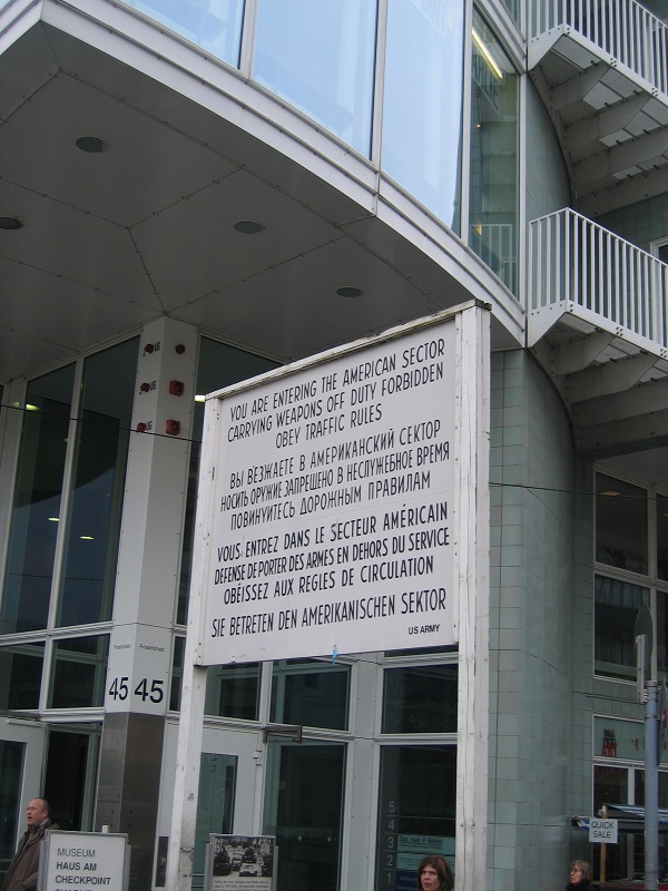
Checkpoint Charlie (or “Checkpoint C”) was the best-known Berlin Wall crossing point between East Berlin and West Berlin during the Cold War (1947–1991), located at the junction of Friedrichstraße with Zimmerstraße and Mauerstraße (which for older historical reasons coincidentally means ‘Wall Street’). It is in the Friedrichstadt neighborhood. Checkpoint Charlie was designated as the single crossing point (on foot or by car) for foreigners and members of the Allied forces. (Members of the Allied forces were not allowed to use the other sector crossing point designated for use by foreigners, the Friedrichstraße railway station).
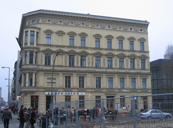
As the most visible Berlin Wall checkpoint, Checkpoint Charlie was featured in movies and books. A famous cafe and viewing place for Allied officials, armed forces and visitors alike, Cafe Adler (“Eagle Café”), was situated right on the checkpoint.
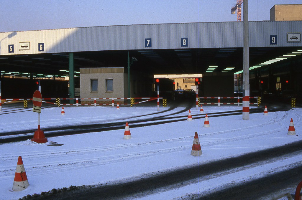
The development of the infrastructure around the checkpoint was largely asymmetrical, reflecting the contrary priorities of East German and Western border authorities. During its 28-year active life, the infrastructure on the Eastern side was expanded to include not only the wall, watchtower and zig-zag barriers, but a multi-lane shed where cars and their occupants were checked. However, the Allied authority never erected any permanent buildings. A wooden shed was replaced during the 1980s by a larger metal structure, now displayed at the Allied Museum in western Berlin. Their reasoning was that they did not consider the inner Berlin sector boundary an international border and did not treat it as such.
in 1986

in 2006


In 2006 much of the drama has been lost, maybe that’s for the best, but the excellent museum Haus am Checkpoint Charlie is a great source of information.
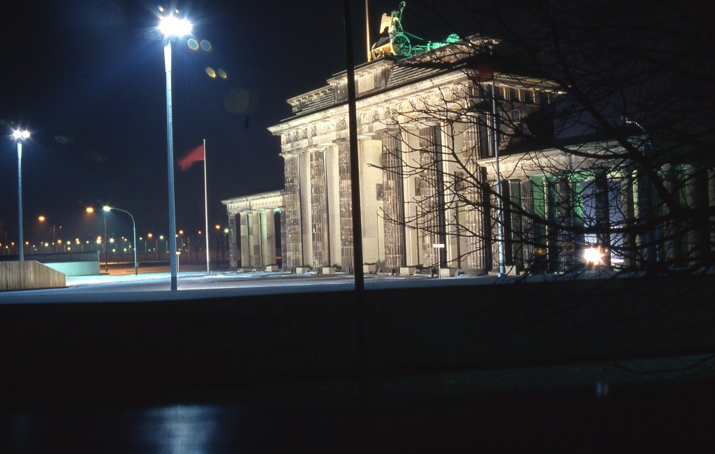
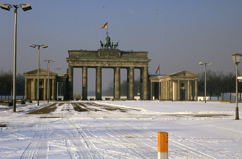
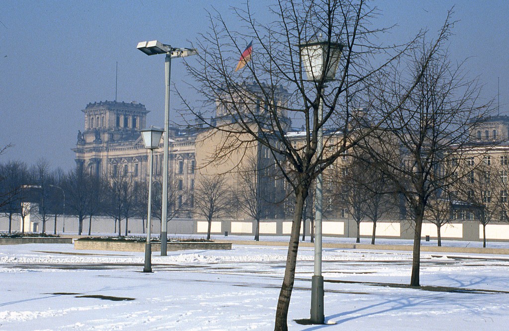
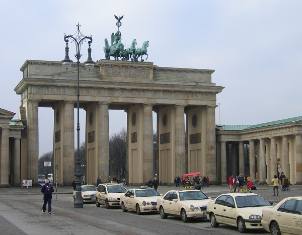
The Brandenburg Gate
The Brandenburg Gate is one of the most iconic sights in today’s vibrant Berlin. More than just Berlin’s only surviving historical city gate, this site came to symbolise Berlin’s Cold War division into East and West – and, since the fall of the Wall, a reunified Germany. Constructed between 1788 and 1791, the Brandenburg Gate was Berlin’s first Greek revival building. The Brandenburg Gate is 26 metres high, 65.5 metres long and 11 metres deep, and supported by two rows of six Doric columns. In 1946, with the post-war division of Germany and Berlin, the Brandenburg Gate was in the Soviet sector. When the Berlin Wall went up in 1961, the Gate stood in an exclusion zone in an arc of the Wall, inaccessible for locals and visitors alike. When the Wall fell, 100,000 people gathered here for the Brandenburg Gate’s official opening on 22 December 1989 – and soon afterwards, crowds thronged the area to celebrate their first joint New Year’s Eve in this once-divided city. Today, more than almost any other of the city’s landmark sights, the Brandenburg Gate symbolises a reunited Berlin.
in 1986


in 2006

Easy to walk from east to west, a 5 minute journey that in 1986 took 3 hours via Checkpoint Charlie. Adjacent to the Brandenburg Gate the US embassy was being built in 2008. Photos here.
Glienicke Bridge
The Glienicke Bridge (German: Glienicker Brücke) is a bridge across the Havel River in Germany, connecting the Wannsee district of Berlin with the Brandenburg capital Potsdam. During the Cold War, as this portion of the Havel River formed the border between West Berlin and East Germany, the bridge was used several times for the exchange of captured spies and thus became known as the Bridge of Spies.
The bridge was closed to East German citizens after the construction of the Berlin Wall in August 1961. Only Allied military personnel and foreign diplomats were allowed to access the bridge at any time. Of all the checkpoints between West Berlin and East Berlin, as well as those between West Berlin and East Germany, the Glienicke Bridge had the uniqueness of being the only such checkpoint of not only having a Soviet presence, but also of being under full Soviet control; all other checkpoints were under East German control, and had no Soviet presence.
By the 1970s, the bridge had outlived its projected lifespan and needed significant repairs. The cost of these repairs became a focus of a dispute between the government of West Berlin and the government of East Germany. In 1980 the West Berlin government repaired its half of the bridge, and in 1985 the West Berlin government paid for repairs to the East German half of the bridge in exchange for formally renaming the bridge “Glienicke Bridge” from “Bridge of Unity.” On the evening of 10 November 1989, one day after the opening of the Berlin Wall, the Glienicke Bridge was reopened for pedestrians. Border fortifications and barricades were dismantled as a part of German reunification in 1990.
in 1986


Note the DDR shield on their side of the bridge. At the time of my visit in 1986 there were no vehicles crossing, although it looked as if cars had crossed that day. Along with Checkpoint Charlie this was the most evocative place for me on the wall.


in 2006


Steinstücken
in 1986
Steinstücken is a small settlement with approximately 200 inhabitants, is the southernmost territory of the Berlin borough of Steglitz-Zehlendorf, belonging to Wannsee. From the division of Germany in 1949 until a connecting corridor was created in 1971–72, Steinstücken was the only permanently inhabited of twelve original exclaves of West Berlin in East Germany, while West Berlin itself was an enclave controlled by the Western Allies, surrounded either by East Berlin or East German (GDR) territory.


In 1951, the GDR attempted to annex Steinstücken by sending police and military forces into the exclave. After objection by the United States, they withdrew their forces a few days later. After this event, access of the inhabitants into surrounding East Germany was prohibited. From then on their only access to the outside world was through two East German checkpoints and a road of about 1 km length into West Berlin proper.
After the building of the Berlin Wall in 1961, Steinstücken became the focus of several escape attempts; as a tiny exclave within East German territory it was demarcated only by barbed wire barriers. After more than twenty East German border guards escaped to the west through Steinstücken, the communist regime in East Germany built a wall around Steinstücken to cut off this escape route.
In 1971 there was a land (and monetary exchange) which led to the road becoming part of West Berlin with the wall on either side.
At the bottom of the wall there was a gap where a single train line went through, to transport waste to dumps within East Germany, for money of course. Looking at photos I think I was standing in East Germany which on reflection was not the most sensible thing to do!


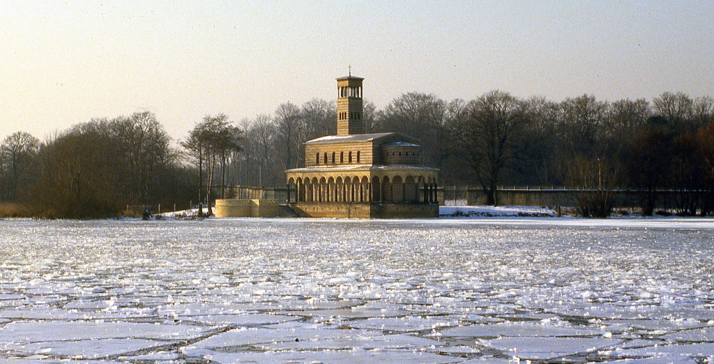
Heilandskirche, Sacrow.
The Protestant Church of the Redeemer is situated on the bank of lake Jungfernsee, a part of the river Havel. The building of the Berlin Wall in August 1961 led over the following decades to heavy damage to the Church of the Redeemer. The barrier along the border between the East German Democratic Republic (GDR) and West Berlin was built straight across the lot of the church property and the campanile was used as part of the protective wall of concrete. The church nave stood in the foreland between wall and border. In spite of these circumstances, regular services were still held in the church until Christmas Eve 1961. A few days later, the church’s interior, which stood in an area strictly controlled by the GDR border troops, was defiled – almost certainly by the troops. This way the church was made unserviceable. The border authority thus created a reason to seal off the church completely, in order to prevent any escape in that section of the border.
In 1986
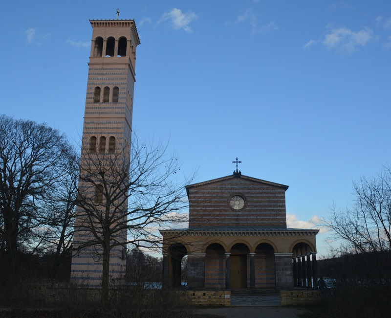
By the end of the 1970s, it became obvious from the West Berlin side of the Havel that the building was in substantial danger. The mayor of West Berlin launched a campaign to save the church and working in collaboration with Church authorities in Brandenberg the exterior of the church was restored in 1984. Sadly many of the interior features were lost.
In November 1989 the Iron Curtain fell, and on Christmas Eve 1989, a service was held once again in the Church of the Redeemer, after almost three decades. The interior was still in a wasted state. From 1993 to 1995 the building was extensively restored. Eight hectares of the garden area had been completely destroyed in the course of fortifying the border and the park of Sacrow Manor was damaged by the building of garages and kennels, as well as the typical border interface for the training of customs dogs. The park was reconstructed after 1994. The Potsdam Havel Landscape has been classified as a World Heritage Site by UNESCO.
in 2014

28 years after seeing this church for the first time I was able to sit in the winter sunshine and remember a time that it would have been at risk of life to be in the same spot. I visited the Church after returning from my Inner German border visit. The church has been wonderfully restored, and I would recommend anyone who visits Belin to visit this spot. Most who do will have no idea of its history as a lost church beyond the wall.

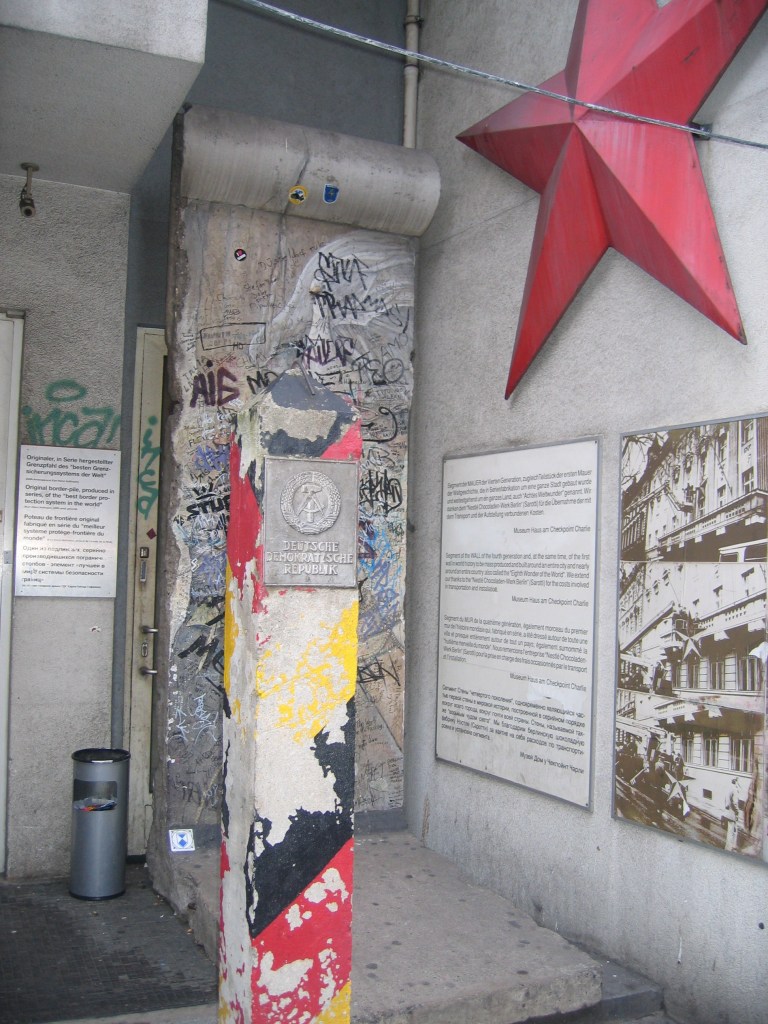
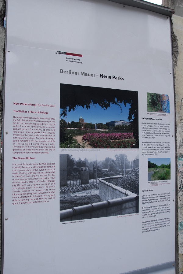
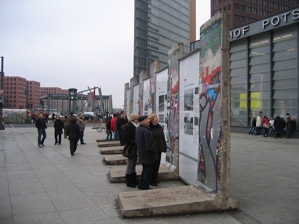
Remnants of the wall in 2006.
After the wall fell, much of it was removed and destroyed. In 2006 there were however remnants and echos of the past, some obvious and some less so. However, if one knew where to look there are elements of the past that stand strangely surrounded by modern day Berlin.
Potsdamer Platz
Potsdamer Platz is a public square and traffic intersection in the center of Berlin, Germany, lying about 1 km south of the Brandenburg Gate and the Bundestag, it was totally destroyed during World War II and then left desolate during the Cold War era when the Berlin Wall bisected its former location. Since German reunification, Potsdamer Platz has been the site of major redevelopment projects. One of the last relics from the DDR era can be found in a small side street on Potsdamer Platz – the type “BT 6” watchtower. A concrete exterior, round at the base and octangular above. The watchtower at Potsdamer Platz was erected in 1971. The shooting range stretched from the Tiergarten to the Brandenburg Gate. The tower was manned at all times by two border patrol soldiers working eight-hour watches in cramped conditions.
Today, the watchtower is the last remaining one of its kind. It was listed as a site of historical importance in 2001 and renovation work began 10 years later.


What makes this tower even more special is that it was in 2008 and even more so today surrounded by modern apartment blocks and shopping centres. It stands as a stark reminder of darker days. Elsewhere in Potsdamer Platz there are sections of wall that display the past.


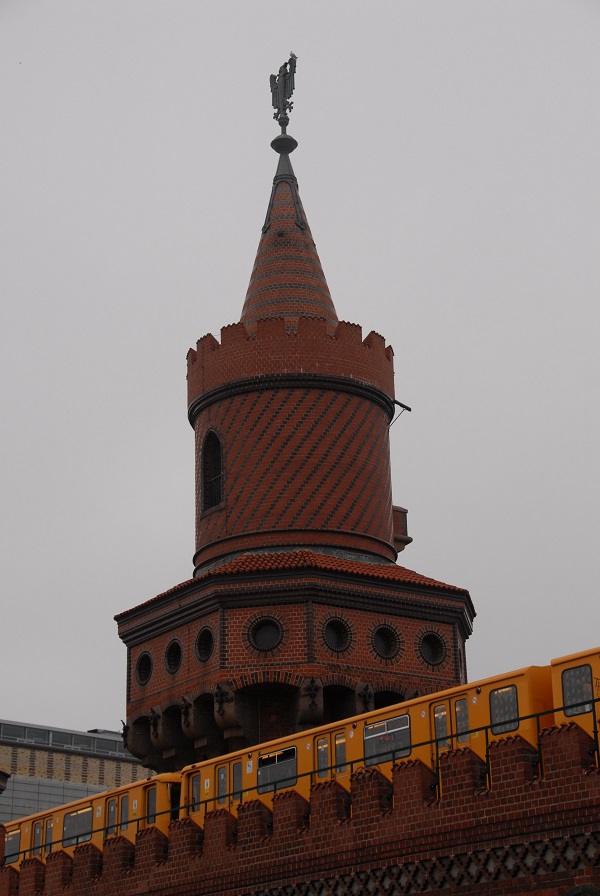
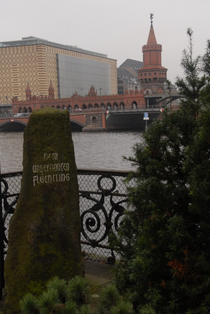
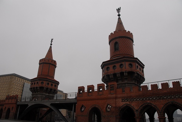
Oberbaumbrücke
The Oberbaum Bridge is a double-deck bridge crossing Berlin’s River Spree, considered one of the city’s landmarks. It links Friedrichshain and Kreuzberg, former boroughs that were divided by the Berlin Wall, and has become an important symbol of Berlin’s unity. The lower deck of the bridge carries a roadway, which connects Oberbaum Straße to the south of the river with Warschauer Straße to the north. The upper deck of the bridge carries Berlin U-Bahn lines Berlin U1 and Berlin U3 between Schlesisches Tor and Warschauer Straße stations. The bridge was a symbol of division between between East and West Germany during the Cold War. Armed guards patrolled the border area on the banks of the Spree River as a border area and the Oberbaum Bridge was one of the few crossover checkpoints from West to East where west German citizens were able to cross pedestrians.
The part of the subway viaduct crossing the Stralauer Allee at the bridge was completely demolished. The towers were demolished in the 1970s. After the removal of the Berlin Wall in 1989, and German reunification the following year, the bridge was rebuilt and restored to the former appearance, albeit with a new steel middle section designed by the Spanish architect Santiago Calatrava. Reconstruction began in January 1992, with the war-damaged parts of the bridge rebuilt. It opened to pedestrians and traffic on 9 November 1994, the fifth anniversary of the opening of the Berlin Wall. The U-Bahn line to Warschauer Straße station was reopened a year later. Since the creation of the unified Friedrichshain-Kreuzberg borough in 2001, the Oberbaum Bridge no longer crosses a jurisdictional boundary.


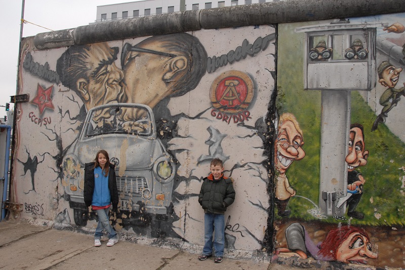
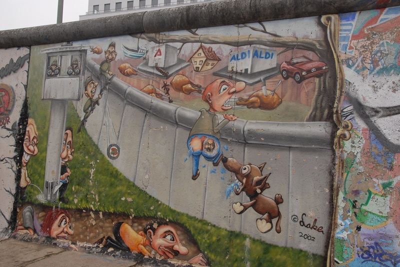
East Side Gallery
The East Side Gallery memorial in Berlin-Friedrichshain is a permanent open-air gallery on the longest surviving section of the Berlin Wall in Mühlenstraße between the Berlin Ostbahnhof and the Oberbaumbrücke along the Spree. It consists of a series of murals painted directly on a 1,316 m long remnant of the Berlin Wall. Immediately after the wall came down, 118 artists from 21 countries began painting the East Side Gallery, and it officially opened as an open air gallery on 28 September 1990. Just over a year later, it was given protected memorial status. In more than a hundred paintings on what was the east side of the wall, the artists commented on the political changes in 1989/90. Some of the works at the East Side Gallery are particularly popular, such as Dmitri Vrubel’s Fraternal Kiss and Birgit Kinders’s Trabant breaking through the wall.
The actual border at this point was the Kreuzberg bank of the Spree. The gallery is located on the so-called hinterland wall, which closed off the border area to East Berlin. Mühlenstrasse, one of the main arterial roads to the south, ran along these border installations.


In 2008 the whole area was a little neglected and was being refurbished. It remains the longest piece of Berlin Wall in existence.

The Berlin Wall – in other places
Many sections of the Berlin Wall and been loaned or gifted across the world. 5 sections are in South Korea, understandably sending a message to the division there. There are now more segments outside Germany than within it, and it is possible to find sections in the most unexpected of places. Recently I have made an effort of visiting these sections on my travels. Christchurch, New Zealand is the furthest away whereas a Buddhist Temple in Osaka perhaps the most unexpected place. Please click on the image below or here to access images of the wall far from home.


what a great report on one of the most famous buildings from a divided Germany! Impressive👍😍
LikeLiked by 1 person